IMAGES TAKEN NEAR TO
Riby Road, MARKET RASEN, LN7 6RL
Introduction
This page details the photographs taken nearby to Riby Road, LN7 6RL by members of the Geograph project.
The Geograph project started in 2005 with the aim of publishing, organising and preserving representative images for every square kilometre of Great Britain, Ireland and the Isle of Man.

There are currently over 7.5m images from over14,400 individuals and you can help contribute to the project by visiting https://www.geograph.org.uk
Image Map
Images are licensed for reuse under creativecommons.org/licenses/by-sa/2.0
Notes
- Clicking on the map will re-center to the selected point.
- The higher the marker number, the further away the image location is from the centre of the postcode.
Image Listing (23 Images Found)
Images are licensed for reuse under creativecommons.org/licenses/by-sa/2.0
Image
Details
Distance
1
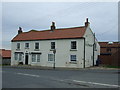
Lincolnshire Montessori School, Caistor
Formerly the Fleece Inn.
Image: © JThomas
Taken: 12 Apr 2014
0.07 miles
2
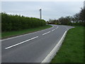
A bend in the A1173
Heading south, Caistor.
Image: © JThomas
Taken: 12 Apr 2014
0.07 miles
3
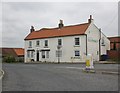
Lincolnshire Montessori School, Caistor
Formerly the Fleece Inn.
Image: © Roger Cornfoot
Taken: 25 May 2015
0.08 miles
4
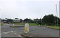
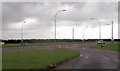
Complex junction on Grimsby Road, Caistor
Image: © David Howard
Taken: 24 Jun 2019
0.09 miles
5
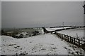
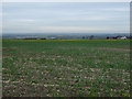
Water Hills
Footpath to Canada across Water Hills east of Caistor
Image: © Richard Croft
Taken: 9 Feb 2007
0.09 miles
6
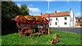
Caistor - Waggon of flowers at jct of A1173 & A1084
Image: © Colin Park
Taken: 23 Aug 2021
0.09 miles
7
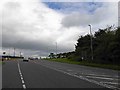
Grimsby Road at the junction of the Caistor By-pass
Image: © David Howard
Taken: 24 Jun 2019
0.09 miles