IMAGES TAKEN NEAR TO
Market Place, MARKET RASEN, LN7 6QE
Introduction
This page details the photographs taken nearby to Market Place, LN7 6QE by members of the Geograph project.
The Geograph project started in 2005 with the aim of publishing, organising and preserving representative images for every square kilometre of Great Britain, Ireland and the Isle of Man.

There are currently over 7.5m images from over14,400 individuals and you can help contribute to the project by visiting https://www.geograph.org.uk
Image Map
Images are licensed for reuse under creativecommons.org/licenses/by-sa/2.0
Notes
- Clicking on the map will re-center to the selected point.
- The higher the marker number, the further away the image location is from the centre of the postcode.
Image Listing (168 Images Found)
Images are licensed for reuse under creativecommons.org/licenses/by-sa/2.0
Image
Details
Distance
1
Foundation Stone
Laid in 1887 for the public hall
Image: © Richard Croft
Taken: 19 Jul 2007
0.01 miles
3
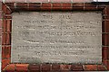
Caistor Public Hall: Commemoration
"This hall was erected by public subscription to commemorate the fiftieth year of the reign of Her Majesty Queen Victoria. This memorial stone was laid on the twenty-sixth day of December 1887 by Miss M.A. Marris. John Johnson Architect. Jolland Chapman Builder."
Image: © Chris
Taken: 1 Apr 2013
0.01 miles
4
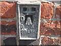
Ordnance Survey Flush Bracket S6418
This bracket can be found on the wall of the Town Hall
For more detail see : http://www.bench-marks.org.uk/bm11887
Image: © Peter Wood
Taken: 30 May 2012
0.01 miles
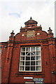
5
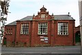
Public Hall
Built on High Street in 1887
Image: © Richard Croft
Taken: 19 Jul 2007
0.02 miles
7
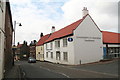
The Talbot lives!
This former, very old pub was closed by 2007, the date of Richard Croft's photo Image
Yet unlike the hunting dog after which it was named, the Talbot is not quite extinct: it lives on with a new identity: The Co-op!
See also: Image
Image: © Chris
Taken: 29 Mar 2013
0.02 miles
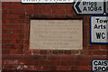
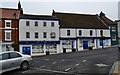
9
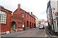
View up the High Street
The entrance to the Public Hall is bottom left.
Image: © Chris
Taken: 29 Mar 2013
0.02 miles
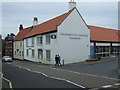
10
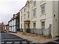
Plough Hill, Caistor
This house, built in the 1600s, is now an apartment block. It was spruced-up during the regeneration scheme and has kept (up to the time of this photograph) quite clean.
Image: © Dave Hitchborne
Taken: 13 Apr 2009
0.02 miles