IMAGES TAKEN NEAR TO
North Kelsey, MARKET RASEN, LN7 6PU
Introduction
This page details the photographs taken nearby to LN7 6PU by members of the Geograph project.
The Geograph project started in 2005 with the aim of publishing, organising and preserving representative images for every square kilometre of Great Britain, Ireland and the Isle of Man.

There are currently over 7.5m images from over14,400 individuals and you can help contribute to the project by visiting https://www.geograph.org.uk
Image Map (Loading...)


Getting Data...Please wait
Leaflet Map data © OpenStreetMap
Images are licensed for reuse under creativecommons.org/licenses/by-sa/2.0
Notes
- Clicking on the map will re-center to the selected point.
- The higher the marker number, the further away the image location is from the centre of the postcode.
Image Listing (7 Images Found)
Images are licensed for reuse under creativecommons.org/licenses/by-sa/2.0
Image
Details
Distance
2
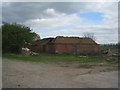
Derelict farm buildings, Highfield Farm
Replaced by modern building just to the right of this picture
Image: © Jonathan Thacker
Taken: 26 Apr 2010
0.02 miles
4
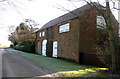
Highfield House
Outbuilding of Highfield House, which looks as if at one time it accommodated wagons to the left, stabling to the right, with room for storing hay in the loft.
Image: © Kate Nicol
Taken: 31 Jan 2010
0.09 miles
5
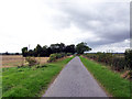
Near Highfield House
Picture taken on Southfield Road. Highfield House is concealed by the shelter belt.
Image: © David Wright
Taken: 3 Sep 2006
0.15 miles
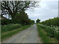
6
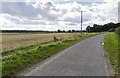
Southfield Road
Looking west with Highfield Plantation on the left.
Image: © Julian P Guffogg
Taken: 4 Sep 2016
0.18 miles
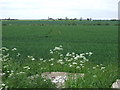
7
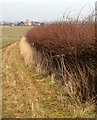
Hedgerow looking North
The tower of Bluebell Mill can be seen on the horizon
Image: © Kate Nicol
Taken: 31 Jan 2010
0.19 miles