IMAGES TAKEN NEAR TO
Lucius Walk, MARKET RASEN, LN7 6GR
Introduction
This page details the photographs taken nearby to Lucius Walk, LN7 6GR by members of the Geograph project.
The Geograph project started in 2005 with the aim of publishing, organising and preserving representative images for every square kilometre of Great Britain, Ireland and the Isle of Man.

There are currently over 7.5m images from over14,400 individuals and you can help contribute to the project by visiting https://www.geograph.org.uk
Image Map
Images are licensed for reuse under creativecommons.org/licenses/by-sa/2.0
Notes
- Clicking on the map will re-center to the selected point.
- The higher the marker number, the further away the image location is from the centre of the postcode.
Image Listing (14 Images Found)
Images are licensed for reuse under creativecommons.org/licenses/by-sa/2.0
Image
Details
Distance
1
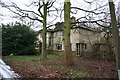
Caistor Hospital
http://www.caistor.free-online.co.uk/hospital.htm
Image: © Richard Croft
Taken: 9 Feb 2007
0.01 miles
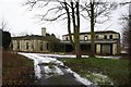
2
Caistor Hospital
http://www.caistor.free-online.co.uk/hospital.htm
Image: © Richard Croft
Taken: 9 Feb 2007
0.01 miles
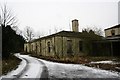
3
Caistor Hospital
Established as the Caistor Union Workhouse in 1836, it became Caistor Hospital in 1937 until 1990 http://www.caistor.free-online.co.uk/hospital.htm it has been empty, derelict and vandalised for many years
Image: © Richard Croft
Taken: 9 Feb 2007
0.02 miles
4
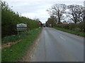
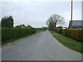
Entering Caistor
Heading east on North Kelsey Road (Roman Road).
Image: © JThomas
Taken: 12 Apr 2014
0.08 miles
5
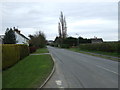
Moor Lane, Caistor
Looking north from North Kelsey Road (Roman Road).
Image: © JThomas
Taken: 12 Apr 2014
0.14 miles
6

N.Kelsey Road (Roman Road)
A glimpse of the town of Caistor on the hill between the trees.
Image: © Chris
Taken: 6 Sep 2013
0.15 miles
7
North Kelsey Road, Caistor
Old Roman Road heading east.
Image: © JThomas
Taken: 12 Apr 2014
0.15 miles
8
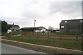
Caistor Riding School and Event Centre
Opposite the end of Moor Lane.
Image: © Chris
Taken: 29 Mar 2013
0.16 miles
9
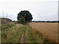
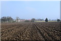
Path between the barley and the new development
Image: © David Brown
Taken: 19 Aug 2020
0.16 miles
10
Field footpath.
A slightly muddy crossing.
Image: © steven ruffles
Taken: 15 Apr 2018
0.17 miles