IMAGES TAKEN NEAR TO
Riby Road, MARKET RASEN, LN7 6DP
Introduction
This page details the photographs taken nearby to Riby Road, LN7 6DP by members of the Geograph project.
The Geograph project started in 2005 with the aim of publishing, organising and preserving representative images for every square kilometre of Great Britain, Ireland and the Isle of Man.

There are currently over 7.5m images from over14,400 individuals and you can help contribute to the project by visiting https://www.geograph.org.uk
Image Map (Loading...)


Getting Data...Please wait
Leaflet Map data © OpenStreetMap
Images are licensed for reuse under creativecommons.org/licenses/by-sa/2.0
Notes
- Clicking on the map will re-center to the selected point.
- The higher the marker number, the further away the image location is from the centre of the postcode.
Image Listing (7 Images Found)
Images are licensed for reuse under creativecommons.org/licenses/by-sa/2.0
Image
Details
Distance
1
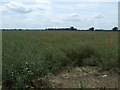
Oilseed rape crop, Swallow Mount
Off the A1173.
Image: © JThomas
Taken: 5 Jul 2014
0.15 miles
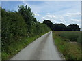
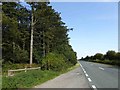
3
Riby Road (A1173)
Heading south west towards Caistor.
Image: © JThomas
Taken: 5 Jul 2014
0.19 miles
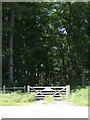
6
Wood Gate
The wooden gate gives access to the private woodland called New Close Wood.
Image: © Michael Patterson
Taken: 26 Sep 2006
0.22 miles
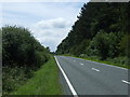
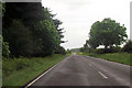
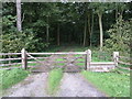
7
Woodland (private) alongside A1173 Riby Road
Image: © Steve Fareham
Taken: 11 Sep 2015
0.22 miles