IMAGES TAKEN NEAR TO
Tomlinson Close, MARKET RASEN, LN7 6DF
Introduction
This page details the photographs taken nearby to Tomlinson Close, LN7 6DF by members of the Geograph project.
The Geograph project started in 2005 with the aim of publishing, organising and preserving representative images for every square kilometre of Great Britain, Ireland and the Isle of Man.

There are currently over 7.5m images from over14,400 individuals and you can help contribute to the project by visiting https://www.geograph.org.uk
Image Map (Loading...)


Getting Data...Please wait
Leaflet Map data © OpenStreetMap
Images are licensed for reuse under creativecommons.org/licenses/by-sa/2.0
Notes
- Clicking on the map will re-center to the selected point.
- The higher the marker number, the further away the image location is from the centre of the postcode.
Image Listing (64 Images Found)
Images are licensed for reuse under creativecommons.org/licenses/by-sa/2.0
Image
Details
Distance
3
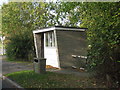
Swallow bus shelter
No advertised services.
Image: © Jonathan Thacker
Taken: 24 Oct 2011
0.05 miles
5
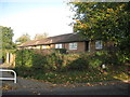
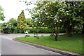
Yarborough Close
Former council bungalows for the elderly.
Image: © Jonathan Thacker
Taken: 24 Oct 2011
0.05 miles
6
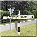
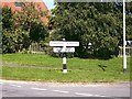
Direction Sign ? Signpost
Located on the southeast side of the junction of Cuxwold Road, Limber Road, Chapel Lane and Beelsby Road in Swallow parish. 3 arms and no finial. See also https://www.geograph.org.uk/photo/1028049.
Milestone Society National ID: LI_TA1702
Image: © D Phillips
Taken: 15 Aug 2019
0.06 miles
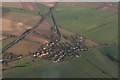
8
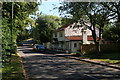
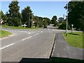
Beelsby Road Junction, Swallow
Situated on the southern edge of the village, the right hand road leads to Cuxwold
Image: © John Beal
Taken: 27 Sep 2008
0.06 miles
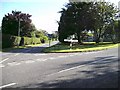
9
Crossroads, Swallow, Lincs
The old A46 continues on its old course ahead, but is now a no through road. The left turn leads to either the by-pass or Great Limber; to the right Cuxwold and Rothwell.
Image: © John Beal
Taken: 1 Sep 2007
0.06 miles
10
Signs of change, Swallow, Lincs
Fine example of the clear, old-type road sign, showing "no through road" where once the A46 would have been signposted.
Image: © John Beal
Taken: 1 Sep 2007
0.06 miles