IMAGES TAKEN NEAR TO
Avondale, LINCOLN, LN6 9SL
Introduction
This page details the photographs taken nearby to Avondale, LN6 9SL by members of the Geograph project.
The Geograph project started in 2005 with the aim of publishing, organising and preserving representative images for every square kilometre of Great Britain, Ireland and the Isle of Man.

There are currently over 7.5m images from over14,400 individuals and you can help contribute to the project by visiting https://www.geograph.org.uk
Image Map
Images are licensed for reuse under creativecommons.org/licenses/by-sa/2.0
Notes
- Clicking on the map will re-center to the selected point.
- The higher the marker number, the further away the image location is from the centre of the postcode.
Image Listing (8 Images Found)
Images are licensed for reuse under creativecommons.org/licenses/by-sa/2.0
Image
Details
Distance
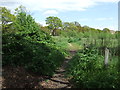
3
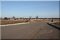
Destined for development
Land at Chapel Farm, North Hykeham, already with a road infrastructure, destined for development in the next few years
Image: © Richard Croft
Taken: 14 Jan 2012
0.19 miles
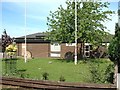
4
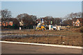
Chapel Farm development land
Land at Chapel Farm, North Hykeham, already with a road infrastructure, destined for development in the next few years
Image: © Richard Croft
Taken: 14 Jan 2012
0.20 miles