IMAGES TAKEN NEAR TO
Crow Park, LINCOLN, LN6 9NN
Introduction
This page details the photographs taken nearby to Crow Park, LN6 9NN by members of the Geograph project.
The Geograph project started in 2005 with the aim of publishing, organising and preserving representative images for every square kilometre of Great Britain, Ireland and the Isle of Man.

There are currently over 7.5m images from over14,400 individuals and you can help contribute to the project by visiting https://www.geograph.org.uk
Image Map (Loading...)


Getting Data...Please wait
Leaflet Map data © OpenStreetMap
Images are licensed for reuse under creativecommons.org/licenses/by-sa/2.0
Notes
- Clicking on the map will re-center to the selected point.
- The higher the marker number, the further away the image location is from the centre of the postcode.
Image Listing (9 Images Found)
Images are licensed for reuse under creativecommons.org/licenses/by-sa/2.0
Image
Details
Distance
2
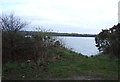
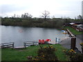
Looking towards flooded gravel pit, Crow Park Farm
Image: © JThomas
Taken: 19 Apr 2012
0.07 miles
6

Sunset over Teal Lake
Photo taken from the Teal Lake extension path from Whisby Nature Park
Image: © John Bennett
Taken: 5 Dec 2007
0.22 miles
8
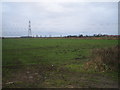
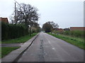
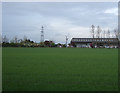
Field from Thorpe Lane
Looking south west from Thorpe Lane. Thorpe-on-the-Hill is in the background to the right.
Image: © Matthew Smith
Taken: 27 Jan 2006
0.22 miles
9

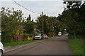
Christmas is coming!
The garden centres begin cut tree sales from late November, as here at Pennell's.
Image: © Jonathan Billinger
Taken: 23 Nov 2018
0.25 miles