IMAGES TAKEN NEAR TO
Manor Road, LINCOLN, LN6 9LS
Introduction
This page details the photographs taken nearby to Manor Road, LN6 9LS by members of the Geograph project.
The Geograph project started in 2005 with the aim of publishing, organising and preserving representative images for every square kilometre of Great Britain, Ireland and the Isle of Man.

There are currently over 7.5m images from over14,400 individuals and you can help contribute to the project by visiting https://www.geograph.org.uk
Image Map (Loading...)


Getting Data...Please wait
Leaflet Map data © OpenStreetMap
Images are licensed for reuse under creativecommons.org/licenses/by-sa/2.0
Notes
- Clicking on the map will re-center to the selected point.
- The higher the marker number, the further away the image location is from the centre of the postcode.
Image Listing (18 Images Found)
Images are licensed for reuse under creativecommons.org/licenses/by-sa/2.0
Image
Details
Distance
1
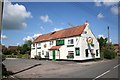
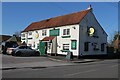
The Plough
Popular hostelry in Swinderby
Image: © Richard Croft
Taken: 25 May 2006
0.08 miles
2
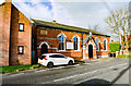
Wesleyan Chapel and School, Swinderby
Built in 1869, it closed in 1998. Now the home of "Light and Life Missions", part of Newark Christian Fellowship.
Image: © Julian P Guffogg
Taken: 16 Nov 2020
0.08 miles
3
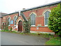
Light and Life Mission Hall
Current use for a Victorian Wesleyan chapel and school.
On the High Street, Swinderby.
Image: © Jonathan Billinger
Taken: 30 Mar 2011
0.08 miles
4
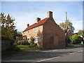
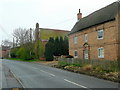
25 High Street, Swinderby
Typical cottage of this area but much altered.
Image: © Jonathan Thacker
Taken: 28 Oct 2011
0.09 miles
5
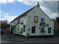
The Plough Inn, High street, Swinderby
Image: © J.Hannan-Briggs
Taken: 19 Feb 2012
0.09 miles
6
Village houses
Substantial buildings on High Street, Swinderby.
Image: © Jonathan Billinger
Taken: 30 Mar 2011
0.09 miles
7
Holt Farm, Swinderby
The large (cast iron ?) panel in the centre of the upper floor seems to say Holt Farm 1740.
Image: © Jonathan Thacker
Taken: 28 Oct 2011
0.10 miles
9
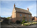
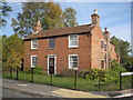
Hurst Farm House, Swinderby
One of Swinderby's older more substantial houses. It is a shame that the roof has been replaced with asbestos tiles rather than the clay pantiles which are usual in older buildings in this area. http://www.britishlistedbuildings.co.uk/en-192168-hurst-farm-house-swinderby
Image: © Jonathan Thacker
Taken: 28 Oct 2011
0.11 miles
10
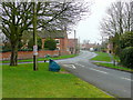
South end of Swinderby village
Looking north along High Street from the junction with Cow Lane and Collingham Road.
Image: © Jonathan Billinger
Taken: 30 Mar 2011
0.15 miles