IMAGES TAKEN NEAR TO
The Paddocks, LINCOLN, LN6 9LH
Introduction
This page details the photographs taken nearby to The Paddocks, LN6 9LH by members of the Geograph project.
The Geograph project started in 2005 with the aim of publishing, organising and preserving representative images for every square kilometre of Great Britain, Ireland and the Isle of Man.

There are currently over 7.5m images from over14,400 individuals and you can help contribute to the project by visiting https://www.geograph.org.uk
Image Map
Images are licensed for reuse under creativecommons.org/licenses/by-sa/2.0
Notes
- Clicking on the map will re-center to the selected point.
- The higher the marker number, the further away the image location is from the centre of the postcode.
Image Listing (28 Images Found)
Images are licensed for reuse under creativecommons.org/licenses/by-sa/2.0
Image
Details
Distance
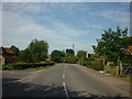

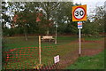
3
Norton Road at Hall Lodge Gardens, Stapleford
Image: © Ian S
Taken: 21 Aug 2021
0.06 miles
4
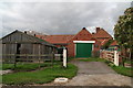
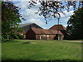
Outbuildings with log store at The Hall, Stapleford
Image: © Tim Heaton
Taken: 20 Jul 2014
0.09 miles
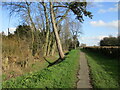
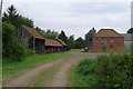
7
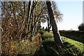
Stapleford
Looking east along the stream by the Hall with All Saints' church in the distance
Image: © Richard Croft
Taken: 18 Nov 2006
0.13 miles
8
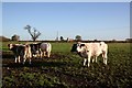
Cattle at Stapleford
In a field by the Laurels with All Saints' church in the distance
Image: © Richard Croft
Taken: 18 Nov 2006
0.15 miles
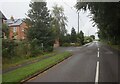
9
Green area in Stapleford
Recently re-seeded and a tree seat added.
Image: © Chris
Taken: 26 Oct 2013
0.16 miles