IMAGES TAKEN NEAR TO
South Scarle Lane, LINCOLN, LN6 9JA
Introduction
This page details the photographs taken nearby to South Scarle Lane, LN6 9JA by members of the Geograph project.
The Geograph project started in 2005 with the aim of publishing, organising and preserving representative images for every square kilometre of Great Britain, Ireland and the Isle of Man.

There are currently over 7.5m images from over14,400 individuals and you can help contribute to the project by visiting https://www.geograph.org.uk
Image Map (Loading...)


Getting Data...Please wait
Leaflet Map data © OpenStreetMap
Images are licensed for reuse under creativecommons.org/licenses/by-sa/2.0
Notes
- Clicking on the map will re-center to the selected point.
- The higher the marker number, the further away the image location is from the centre of the postcode.
Image Listing (8 Images Found)
Images are licensed for reuse under creativecommons.org/licenses/by-sa/2.0
Image
Details
Distance
1
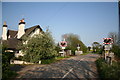
South Scarle Crossing
On Bulpit Lane between South Scarle and Swinderby
Image: © Richard Croft
Taken: 11 May 2006
0.00 miles
2
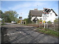
South Scarle Crossing
On Bulpit Lane which Network Rail spells as Bull Pit Lane. The crossing house is typical of those built by the Midland Railway in 1846 when this line was opened.
Image: © Jonathan Thacker
Taken: 28 Oct 2011
0.01 miles
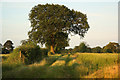
3
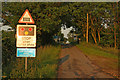
South Scarle Crossing
Evening sunshine on South Scarle Lane approaching the level crossing
Image: © Richard Croft
Taken: 5 Jul 2012
0.01 miles
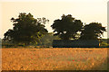
4
South Scarle Crossing House
Crossing house seen from Meardsall Lane
Image: © Richard Croft
Taken: 1 Jun 2009
0.02 miles
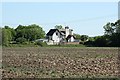
5
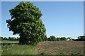
Meardsall view
Farmland off Meardsall Lane
Image: © Richard Croft
Taken: 1 Jun 2009
0.08 miles
6
Field of barley
Towards Bulpit Lane near Swinderby
Image: © Richard Croft
Taken: 5 Jul 2012
0.15 miles
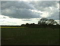
8
Farm track
Track between Bulpit Lane and Station Road near Swinderby
Image: © Richard Croft
Taken: 5 Jul 2012
0.25 miles