IMAGES TAKEN NEAR TO
Hives Lane, LINCOLN, LN6 9HA
Introduction
This page details the photographs taken nearby to Hives Lane, LN6 9HA by members of the Geograph project.
The Geograph project started in 2005 with the aim of publishing, organising and preserving representative images for every square kilometre of Great Britain, Ireland and the Isle of Man.

There are currently over 7.5m images from over14,400 individuals and you can help contribute to the project by visiting https://www.geograph.org.uk
Image Map (Loading...)


Getting Data...Please wait
Leaflet Map data © OpenStreetMap
Images are licensed for reuse under creativecommons.org/licenses/by-sa/2.0
Notes
- Clicking on the map will re-center to the selected point.
- The higher the marker number, the further away the image location is from the centre of the postcode.
Image Listing (16 Images Found)
Images are licensed for reuse under creativecommons.org/licenses/by-sa/2.0
Image
Details
Distance
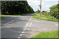
1
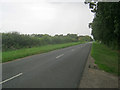
Hives Lane
Heading north-east in a straight line to Wigsley.
Image: © Trevor Rickard
Taken: 21 Aug 2012
0.11 miles
2
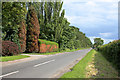
Chapel Lane
Looking towards North Scarle. The hedge on the left is showing signs of severe droughting.
Image: © Alan Murray-Rust
Taken: 15 Jul 2012
0.12 miles
3
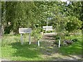
Commemorative seat in North Scarle
Celebrating the Queen's diamond jubilee in 2012
Image: © Graham Hogg
Taken: 12 Sep 2016
0.13 miles
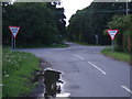
5
Crossroads at Red House Farm
Looking towards Wigsley and Harby.
Image: © Alan Murray-Rust
Taken: 15 Jul 2012
0.14 miles

7
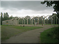
Building shell off Hives Lane
On the east side of the lane. Note sure if it is being developed or demolished.
Image: © Trevor Rickard
Taken: 21 Aug 2012
0.15 miles
8
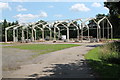
Building Shell off Hives Lane
Whatever is happening, it hasn't changed much since Image
Image: © J.Hannan-Briggs
Taken: 3 Aug 2013
0.16 miles

10
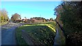
Hives Lane and School Lane at Hunt's Bridge
Image: © Chris Morgan
Taken: 9 Feb 2016
0.20 miles