IMAGES TAKEN NEAR TO
Besthorpe Road, LINCOLN, LN6 9EZ
Introduction
This page details the photographs taken nearby to Besthorpe Road, LN6 9EZ by members of the Geograph project.
The Geograph project started in 2005 with the aim of publishing, organising and preserving representative images for every square kilometre of Great Britain, Ireland and the Isle of Man.

There are currently over 7.5m images from over14,400 individuals and you can help contribute to the project by visiting https://www.geograph.org.uk
Image Map
Images are licensed for reuse under creativecommons.org/licenses/by-sa/2.0
Notes
- Clicking on the map will re-center to the selected point.
- The higher the marker number, the further away the image location is from the centre of the postcode.
Image Listing (6 Images Found)
Images are licensed for reuse under creativecommons.org/licenses/by-sa/2.0
Image
Details
Distance
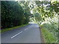
1
Creeping ivy on trees beside Besthorpe Road
Image: © Chris Morgan
Taken: 9 Feb 2016
0.02 miles
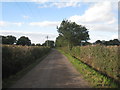
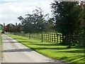
2
Besthorpe Road
Minor road between Besthorpe and North Scarle
Image: © Graham Hogg
Taken: 12 Sep 2016
0.05 miles
3
Rusty old petrol pump beside Besthorpe Road
Image: © Chris Morgan
Taken: 9 Feb 2016
0.08 miles
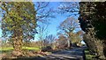
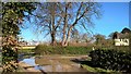
4
The driveway to Field Farm
Also a public footpath to North Scarle
Image: © Graham Hogg
Taken: 12 Sep 2016
0.09 miles
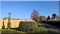
5
End of Folly Lane
A glorious morning, but it followed a very wet day.
Image: © Chris Morgan
Taken: 9 Feb 2016
0.10 miles