IMAGES TAKEN NEAR TO
Swinderby Road, LINCOLN, LN6 9EU
Introduction
This page details the photographs taken nearby to Swinderby Road, LN6 9EU by members of the Geograph project.
The Geograph project started in 2005 with the aim of publishing, organising and preserving representative images for every square kilometre of Great Britain, Ireland and the Isle of Man.

There are currently over 7.5m images from over14,400 individuals and you can help contribute to the project by visiting https://www.geograph.org.uk
Image Map
Images are licensed for reuse under creativecommons.org/licenses/by-sa/2.0
Notes
- Clicking on the map will re-center to the selected point.
- The higher the marker number, the further away the image location is from the centre of the postcode.
Image Listing (80 Images Found)
Images are licensed for reuse under creativecommons.org/licenses/by-sa/2.0
Image
Details
Distance
1
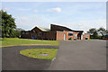
North Scarle sports hall
The sports facilities here are substantial in relation to the size of the village.
Image: © Alan Murray-Rust
Taken: 15 Jul 2012
0.04 miles
2
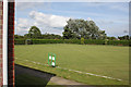
North Scarle recreation grounds
The immaculately prepared bowling greens.
Image: © Alan Murray-Rust
Taken: 15 Jul 2012
0.04 miles
3
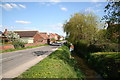
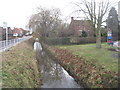
Swinderby Road
Swinderby Road and Mill Dam Dyke, looking south-east
Image: © Richard Croft
Taken: 3 May 2006
0.06 miles
4
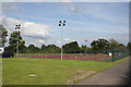
North Scarle recreation grounds
A well appointed set of all-weather tennis courts, with floodlights.
Image: © Alan Murray-Rust
Taken: 15 Jul 2012
0.07 miles
6
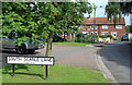
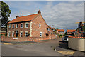
9-21 South Scarle Lane
A typical village development of local authority housing.
Image: © Alan Murray-Rust
Taken: 15 Jul 2012
0.08 miles
7
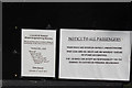
Memories are made of this
Coal smuts from steam locomotives were an inherent feature of my childhood. No journey would be complete without one's head stuck out of the window for a good percentage of the trip.
Image: © Alan Murray-Rust
Taken: 15 Jul 2012
0.09 miles
8
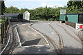
North Scarle miniature railway
Operated by the Lincoln and District Model Railway Society. This is the station and depot.
Image: © Alan Murray-Rust
Taken: 15 Jul 2012
0.09 miles
9
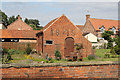
Pear Tree Farm, outbuilding
The date 1846 is prominently displayed in dark brick. Along with the farmhouse http://www.geograph.org.uk/photo/3055019, Listed Grade II.
Image: © Alan Murray-Rust
Taken: 15 Jul 2012
0.09 miles
10
8 Eagle Road, North Scarle
This and the rest of the houses on Eyre's Lane are built in a traditional style.
Image: © Alan Murray-Rust
Taken: 15 Jul 2012
0.09 miles