IMAGES TAKEN NEAR TO
Lincoln Road, LINCOLN, LN6 9DL
Introduction
This page details the photographs taken nearby to Lincoln Road, LN6 9DL by members of the Geograph project.
The Geograph project started in 2005 with the aim of publishing, organising and preserving representative images for every square kilometre of Great Britain, Ireland and the Isle of Man.

There are currently over 7.5m images from over14,400 individuals and you can help contribute to the project by visiting https://www.geograph.org.uk
Image Map (Loading...)


Getting Data...Please wait
Leaflet Map data © OpenStreetMap
Images are licensed for reuse under creativecommons.org/licenses/by-sa/2.0
Notes
- Clicking on the map will re-center to the selected point.
- The higher the marker number, the further away the image location is from the centre of the postcode.
Image Listing (42 Images Found)
Images are licensed for reuse under creativecommons.org/licenses/by-sa/2.0
Image
Details
Distance
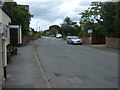
1
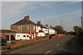
Semi-detached houses on the way out of Eagle
In the direction of Eagle Moor.
Image: © Chris
Taken: 27 Oct 2012
0.02 miles
2
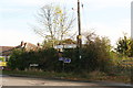
Scarle Lane turn-off, Eagle
Off the Lincoln Road.
Image: © Chris
Taken: 27 Oct 2012
0.04 miles
3

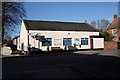
Former Wesleyan Methodist Chapel, Eagle
There is also a former Sunday school, in the same style, to the right.
Image: © Humphrey Bolton
Taken: 10 Sep 2021
0.06 miles
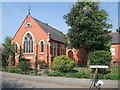
7
The Struggler, Eagle
A curious name for a pub. The sign shows arm wrestling.
Image: © Tim Heaton
Taken: 23 Apr 2011
0.12 miles
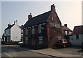
8
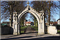
Eagle
1914-18 War Memorial arch and All Saints' church at Eagle
Image: © Richard Croft
Taken: 30 Jan 2010
0.13 miles
9
47 High Street
Ramshackle cottage on High Street, Eagle, which despite its appearance is still occupied
Image: © Richard Croft
Taken: 30 Jan 2010
0.13 miles
10
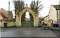
War Memorial Arch
Grade II listed War Memorial Arch to All Saints' Church in Eagle
Image: © Richard Croft
Taken: 30 Dec 2020
0.14 miles