IMAGES TAKEN NEAR TO
Pendine Crescent, LINCOLN, LN6 8UP
Introduction
This page details the photographs taken nearby to Pendine Crescent, LN6 8UP by members of the Geograph project.
The Geograph project started in 2005 with the aim of publishing, organising and preserving representative images for every square kilometre of Great Britain, Ireland and the Isle of Man.

There are currently over 7.5m images from over14,400 individuals and you can help contribute to the project by visiting https://www.geograph.org.uk
Image Map (Loading...)


Getting Data...Please wait
Leaflet Map data © OpenStreetMap
Images are licensed for reuse under creativecommons.org/licenses/by-sa/2.0
Notes
- Clicking on the map will re-center to the selected point.
- The higher the marker number, the further away the image location is from the centre of the postcode.
Image Listing (25 Images Found)
Images are licensed for reuse under creativecommons.org/licenses/by-sa/2.0
Image
Details
Distance
1
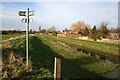
Lowfields walk
Fingerpost for the Lowfields walk at North Hykeham
Image: © Richard Croft
Taken: 22 Jan 2008
0.09 miles
2
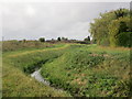
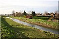
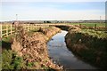
Drain and footpath
The drain is the practical limit on the expansion of North Hykeham. Beyond the bank on the left is the Witham floodplain.
Image: © Jonathan Thacker
Taken: 18 Oct 2014
0.13 miles
3
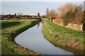
Hykeham Drain
Drain on the edge of the lowfields at North Hykeham
Image: © Richard Croft
Taken: 22 Jan 2008
0.13 miles
4
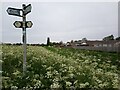
Signpost by a catchwater drain, North Hykeham
A signpost indicating the direction of public footpaths rises above burnet-saxifrage wildflowers, looking northwestwards along the banks of a catchwater drain by the eastern suburbs of North Hykeham.
This photograph was taken on a cool morning in mid-May. For just over a kilometre the catchwater drain (here running parallel to the fences) marks the boundary between North Hykeham's eastern suburbs and the undeveloped floodplain of the River Witham. The estate on the right is primarily composed of bungalows and has no direct access to this walkway.
The footpath from which this image was taken is part of a network of local routes maintained by the Hill Holt Wood charity, as indicated by the lower 'Stepping Out' pair of signs. From this point southwards the path changes from wide and flat to narrow and uneven, and while admiring the view across the Witham floodplain one must take care not to lose one's footing.
For the same view fifteen years earlier, please see Image by Richard Croft.
Image: © Jonathon Pile
Taken: 13 May 2023
0.14 miles
5
Drainside
Drain and the back of houses on Hartland Avenue
Image: © Richard Croft
Taken: 22 Jan 2008
0.14 miles
6
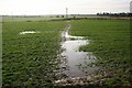
Waterlogged footpath
The aftermath of recent heavy rain
Image: © Richard Croft
Taken: 22 Jan 2008
0.15 miles
7
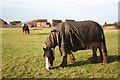
Ponies by the Pump Drain at North Hykeham
Image: © Richard Croft
Taken: 22 Jan 2008
0.15 miles
8
Footpath by the Pump Drain
Muddy drainside footpath at North Hykeham
Image: © Richard Croft
Taken: 22 Jan 2008
0.15 miles
10
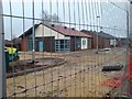
New Fen Lane Medical Centre under construction
Image: © Wendy Parkinson
Taken: 14 Dec 2008
0.17 miles