IMAGES TAKEN NEAR TO
Sunningdale Drive, LINCOLN, LN6 7UD
Introduction
This page details the photographs taken nearby to Sunningdale Drive, LN6 7UD by members of the Geograph project.
The Geograph project started in 2005 with the aim of publishing, organising and preserving representative images for every square kilometre of Great Britain, Ireland and the Isle of Man.

There are currently over 7.5m images from over14,400 individuals and you can help contribute to the project by visiting https://www.geograph.org.uk
Image Map
Images are licensed for reuse under creativecommons.org/licenses/by-sa/2.0
Notes
- Clicking on the map will re-center to the selected point.
- The higher the marker number, the further away the image location is from the centre of the postcode.
Image Listing (21 Images Found)
Images are licensed for reuse under creativecommons.org/licenses/by-sa/2.0
Image
Details
Distance
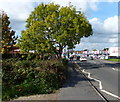
1
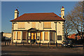
The Victory
Former pub on Boultham Park Road, The Victory was built in 1919 to commemorate the end of the First World War in 1918, closed in 2014.
Image: © Richard Croft
Taken: 14 Jan 2015
0.04 miles
3

Tin Tabernacle
St.Matthew's church in Boultham, a typical 'Tin Tabernacle' of prefabricated timber frame and corrugated iron cladding, built in 1912 with further works undertaken in 1924. It has been redundant since 2000 and is currently in need of a new owner.
Image: © Richard Croft
Taken: 9 Jun 2006
0.17 miles
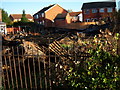
4
Numbers 2 - 8 Church Drive
Taken a day after the fire. Number 2 to right of picture, next to the old St Matthew's Church. The front downpipe has come away where the fire melted plastic.
Image: © Jean Flannery
Taken: 1 Sep 2008
0.19 miles
7
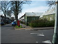
Church Drive From Boultham Park Road
The Old 'Tin Tabernacle' as it stood in April 2008
Image: © Jean Flannery
Taken: 21 Apr 2008
0.21 miles
8
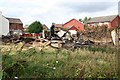
After the fire
Tin tabernacle St.Matthew's church http://www.geograph.org.uk/photo/183598 mysteriously gutted by fire on the night of Saturday 30th August 2008 http://news.bbc.co.uk/1/hi/england/lincolnshire/7591704.stm
Image: © Richard Croft
Taken: 2 Sep 2008
0.22 miles
9
St Matthew's Church Totally Down
October 2008: Church now flattened following the fire
Image: © Jean Flannery
Taken: 27 Oct 2008
0.22 miles
10
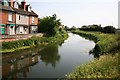
River Witham looking south from Boultham Avenue
Image: © Richard Croft
Taken: 9 Jun 2006
0.22 miles