IMAGES TAKEN NEAR TO
Moorland Way, LINCOLN, LN6 7JW
Introduction
This page details the photographs taken nearby to Moorland Way, LN6 7JW by members of the Geograph project.
The Geograph project started in 2005 with the aim of publishing, organising and preserving representative images for every square kilometre of Great Britain, Ireland and the Isle of Man.

There are currently over 7.5m images from over14,400 individuals and you can help contribute to the project by visiting https://www.geograph.org.uk
Image Map
Images are licensed for reuse under creativecommons.org/licenses/by-sa/2.0
Notes
- Clicking on the map will re-center to the selected point.
- The higher the marker number, the further away the image location is from the centre of the postcode.
Image Listing (18 Images Found)
Images are licensed for reuse under creativecommons.org/licenses/by-sa/2.0
Image
Details
Distance
1
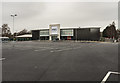
New M&S Foodhall
New Year's Day 2018 at midday.
Image: © Julian P Guffogg
Taken: 1 Jan 2018
0.05 miles
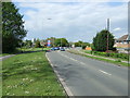
2
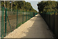
New cycle track
Recently established cycle and pedestrian route by the railway line between Doddington Road and Moorland Way
Image: © Richard Croft
Taken: 28 Sep 2013
0.06 miles


7

Domino's Pizza
Take-away pizzas on Tritton Road
Image: © Richard Croft
Taken: 12 Aug 2009
0.11 miles

10
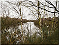
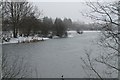
One of Swanholme Lakes
Looking south south west towards Doddington Road.
Image: © Julian P Guffogg
Taken: 1 Jan 2019
0.16 miles