IMAGES TAKEN NEAR TO
Shannon Avenue, LINCOLN, LN6 7JG
Introduction
This page details the photographs taken nearby to Shannon Avenue, LN6 7JG by members of the Geograph project.
The Geograph project started in 2005 with the aim of publishing, organising and preserving representative images for every square kilometre of Great Britain, Ireland and the Isle of Man.

There are currently over 7.5m images from over14,400 individuals and you can help contribute to the project by visiting https://www.geograph.org.uk
Image Map
Images are licensed for reuse under creativecommons.org/licenses/by-sa/2.0
Notes
- Clicking on the map will re-center to the selected point.
- The higher the marker number, the further away the image location is from the centre of the postcode.
Image Listing (15 Images Found)
Images are licensed for reuse under creativecommons.org/licenses/by-sa/2.0
Image
Details
Distance
1

Walking on water
A pair of ducks on a frozen fishing pond
Image: © Richard Croft
Taken: 3 Mar 2006
0.04 miles
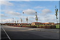
3

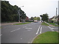
Moorland Avenue under the clouds
Clouds spread across Moorland Avenue, as viewed from Sansford Green.
Image: © Ian Paterson
Taken: 8 Mar 2009
0.11 miles
4

Curved terrace, Turner Avenue/Moorland Avenue
Designed to match the parade of shops opposite Image
Image: © Jonathan Thacker
Taken: 11 Apr 2018
0.15 miles
5
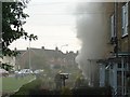
Fire at Sansford Green
Firecrew attending to a blaze in a ground floor flat.
Image: © Ian Paterson
Taken: 8 Sep 2007
0.16 miles
6

Shopping parade Turner Avenue/Moorland Avenue
The curve gives a hint of elegance to an otherwise unexceptional design.
Image: © Jonathan Thacker
Taken: 11 Apr 2018
0.16 miles
8
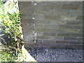
Cut Mark: Lincoln, Peter de Wint PH
Cut bench mark on the pub's storeroom. See http://www.bench-marks.org.uk/bm38375 for details.
Image: © Brian Westlake
Taken: 13 Jun 2011
0.18 miles
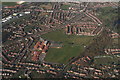
9
Moorland Avenue, Lincoln
Moorland Avenue is the main road through the residential area that dominates this square. The trees on the left of the picture are part of a small wooded area called Boulthan Moor Wood. It is mainly used for fly-tipping and off road motorcycle activity.
Image: © Matthew Smith
Taken: 7 Oct 2005
0.18 miles
10
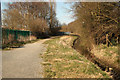
Path by Pike Drain
Footpath and cyclepath between Pike Drain and the Priory Witham Academy
Image: © Richard Croft
Taken: 2 Apr 2013
0.19 miles