IMAGES TAKEN NEAR TO
De Wint Avenue, LINCOLN, LN6 7DP
Introduction
This page details the photographs taken nearby to De Wint Avenue, LN6 7DP by members of the Geograph project.
The Geograph project started in 2005 with the aim of publishing, organising and preserving representative images for every square kilometre of Great Britain, Ireland and the Isle of Man.

There are currently over 7.5m images from over14,400 individuals and you can help contribute to the project by visiting https://www.geograph.org.uk
Image Map (Loading...)


Getting Data...Please wait
Leaflet Map data © OpenStreetMap
Images are licensed for reuse under creativecommons.org/licenses/by-sa/2.0
Notes
- Clicking on the map will re-center to the selected point.
- The higher the marker number, the further away the image location is from the centre of the postcode.
Image Listing (10 Images Found)
Images are licensed for reuse under creativecommons.org/licenses/by-sa/2.0
Image
Details
Distance
2
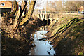
Pike Drain
Pike Drain and culvert under De Wint Avenue
Image: © Richard Croft
Taken: 2 Apr 2013
0.08 miles
3
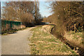
Path by Pike Drain
Footpath and cyclepath between Pike Drain and the Priory Witham Academy
Image: © Richard Croft
Taken: 2 Apr 2013
0.08 miles
6

Snake in the grass
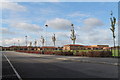
Play equipment at the Priory Witham Academy
Image: © Richard Croft
Taken: 2 Apr 2013
0.16 miles
7

Path by Pike Drain
Footpath and cyclepath between Pikle Drain and The Priory Witham Academy
Image: © Richard Croft
Taken: 2 Apr 2013
0.17 miles