IMAGES TAKEN NEAR TO
Lapwing Close, LINCOLN, LN6 5XS
Introduction
This page details the photographs taken nearby to Lapwing Close, LN6 5XS by members of the Geograph project.
The Geograph project started in 2005 with the aim of publishing, organising and preserving representative images for every square kilometre of Great Britain, Ireland and the Isle of Man.

There are currently over 7.5m images from over14,400 individuals and you can help contribute to the project by visiting https://www.geograph.org.uk
Image Map
Images are licensed for reuse under creativecommons.org/licenses/by-sa/2.0
Notes
- Clicking on the map will re-center to the selected point.
- The higher the marker number, the further away the image location is from the centre of the postcode.
Image Listing (28 Images Found)
Images are licensed for reuse under creativecommons.org/licenses/by-sa/2.0
Image
Details
Distance
1
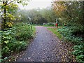
Footpath crossing NCN64 at Skellingthorpe
Image: © Steve Fareham
Taken: 3 Nov 2015
0.14 miles
3

Footpath off Goldfinch Close, Skellingthorpe
Image: © Jonathan Thacker
Taken: 22 Jan 2022
0.15 miles
4
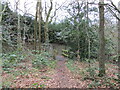
Footpath over a drain, Skellingthorpe
Image: © Jonathan Thacker
Taken: 22 Jan 2022
0.16 miles
5
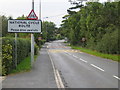
Skellingthorpe
Main road into Skellingthorpe village and warning signs for the national cycle route No.64.
Image: © Matthew Smith
Taken: 19 Sep 2005
0.16 miles
6

National Cycle Network Route 64
No boring long straight sections through Skellingthorpe.
Image: © Ian Paterson
Taken: 22 Feb 2009
0.16 miles

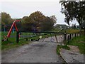
8
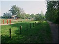
'The Monson' playing fields, Skellingthorpe
Named after Lord Monson. Cycle Route 64 uses the track on the right.
Image: © Tim Heaton
Taken: 23 Apr 2011
0.19 miles
10

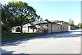
Community Centre and Youth Hall, Lincoln Road, Skellingthorpe
The Community Centre was opened in 1973 on the site of Skellingthorpe railway station that was opened in March 1897 by the Lancashire, Derbyshire and East Coast Railway on its (only) main line from Chesterfield to Lincoln. Absorbed by the Great Central in 1907 the station was closed by British Railways on 19th September 1955 although it carried freight until the line closed completely in February 1980 following a derailment, with the track being lifted in 1981. By 1964 the only buildings that remained were the goods shed, signal box and weigh-bridge office. The weigh-bridge office, used as a lamp room after 1964, appears to be the only remains of the station buildings and is now the Heritage Room.
Image: © Jo and Steve Turner
Taken: 29 Jan 2016
0.21 miles