IMAGES TAKEN NEAR TO
High Street, LINCOLN, LN6 5TS
Introduction
This page details the photographs taken nearby to High Street, LN6 5TS by members of the Geograph project.
The Geograph project started in 2005 with the aim of publishing, organising and preserving representative images for every square kilometre of Great Britain, Ireland and the Isle of Man.

There are currently over 7.5m images from over14,400 individuals and you can help contribute to the project by visiting https://www.geograph.org.uk
Image Map
Images are licensed for reuse under creativecommons.org/licenses/by-sa/2.0
Notes
- Clicking on the map will re-center to the selected point.
- The higher the marker number, the further away the image location is from the centre of the postcode.
Image Listing (49 Images Found)
Images are licensed for reuse under creativecommons.org/licenses/by-sa/2.0
Image
Details
Distance

2
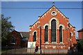
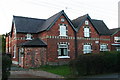
Former village Hall, Skellingthorpe
Photo Image, taken in 2007, shows this as the village hall (built 1928). The present village hall is on Lincoln Road, along with the Skellingthorpe Heritage Building (see:Image).
As the left-hand sign shows, this is now the scout hut. Perhaps the motto "Be Prepared" refers to the skip which has invaded this 2012 photo!
Image: © Chris
Taken: 27 Oct 2012
0.03 miles
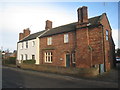
3
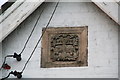
Skellingthorpe cottages: Christ's Hospital coat of arms
See: Image
These estate houses (or former estate cottages) were built thanks to Henry Stone, Lord of the Manor of Skellingthorpe, who is buried in the churchyard.
Henry Stone died in 1693. In his will he gave his Manor and land to Christ's Hospital, London. On the land they built cottages, a school and the pub.
In 1914 Christ's Hospital sold off by Auction all their properties in the Parish.
For more information on the features of Skellingthorpe and their historical significance, have a look at the Skellingthorpe Village Walk: http://www.n-kesteven.gov.uk/visitors/leisure/sports-and-leisure/countryside/countryside-walks/village-walks/skellingthorpe-village-walk/105918.article
Image: © Chris
Taken: 27 Oct 2012
0.05 miles
4
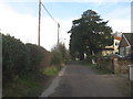
Stoney Lane, Skellingthorpe
Provides access to a handful of bungalows and houses and to the church.
Image: © Jonathan Thacker
Taken: 12 Jan 2013
0.07 miles
5
Stone's Cottages, Skellingthorpe
The date stone in the right gable says it was built in 1871. The left gable bears the Christ's Hospital coat of arms.
These estate houses (or former estate cottages) were built thanks to Henry Stone, Lord of the Manor of Skellingthorpe, who is buried in the churchyard.
Henry Stone died in 1693. In his will he gave his Manor and land to Christ's Hospital, London. On the land they built cottages, a school and the pub.
In 1914 Christ's Hospital sold off by Auction all their properties in the Parish.
For more information on the features of Skellingthorpe and their historical significance, have a look at the Skellingthorpe Village Walk: http://www.n-kesteven.gov.uk/visitors/leisure/sports-and-leisure/countryside/countryside-walks/village-walks/skellingthorpe-village-walk/105918.article
Image: © Chris
Taken: 27 Oct 2012
0.07 miles
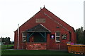
6
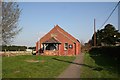
Skellingthorpe village hall
With a datestone of 1928
Image: © Richard Croft
Taken: 25 Mar 2007
0.08 miles
7
Cottages on High Street, Skellingthorpe
Somebody tried hard to make the cottage on the right just a little different from a run-of-the-mill job.
Image: © Jonathan Thacker
Taken: 12 Jan 2013
0.10 miles
8
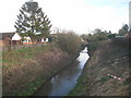
Catchwater Drain
An unlovely name for an unloved (except by ducks) stream running through the centre of Skellingthorpe.
Image: © Jonathan Thacker
Taken: 12 Jan 2013
0.10 miles