
IMAGES TAKEN NEAR TO
Waterloo Lane, LINCOLN, LN6 5SJ
Introduction
This page details the photographs taken nearby to Waterloo Lane, LN6 5SJ by members of the Geograph project.
The Geograph project started in 2005 with the aim of publishing, organising and preserving representative images for every square kilometre of Great Britain, Ireland and the Isle of Man.

There are currently over 7.5m images from over14,400 individuals and you can help contribute to the project by visiting https://www.geograph.org.uk
Image Map
Images are licensed for reuse under creativecommons.org/licenses/by-sa/2.0
Notes
- Clicking on the map will re-center to the selected point.
- The higher the marker number, the further away the image location is from the centre of the postcode.
Image Listing (15 Images Found)
Images are licensed for reuse under creativecommons.org/licenses/by-sa/2.0
Image
Details
Distance
1
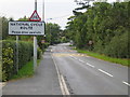
Skellingthorpe
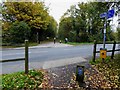
Main road into Skellingthorpe village and warning signs for the national cycle route No.64.
Image: © Matthew Smith
Taken: 19 Sep 2005
0.13 miles
3

Gates, Skellingthorpe
Fine cast-iron gates at the entrance to the hall. The Greek key motif features heavily.
Image: © Stephen Richards
Taken: 16 Jun 2015
0.18 miles
5
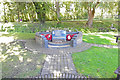
RAF Skellingthorpe Memorial
Skellingthorpe was a bomber airfield within 5 Group, which opened in late 1941. It eventually had the Class "A" intersecting three runways, the main being 1650 yards with two subsidiaries at 1400 yards. There were three hangars, two T2s and a B1. On 26th November 1941, 50 Squadron arrived with their Hampdens from Swinderby, whilst the runways there were re-laid.
It has been completely obliterated by housing and nothing remains; but there are 2 memorials.
https://www.geograph.org.uk/article/Royal-Air-Force-Stations-in-Lincolnshire
Image: © Adrian S Pye
Taken: 17 Sep 2019
0.23 miles
6
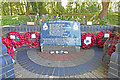
My brief sweet life is over .......
My brief sweet life is over
My eyes no longer see
No Christmas trees, no summer walks
No pretty girls for me
I've got the chop - I've had it
My nightly Ops are done
Yet in another hundred years
I'll still be twenty one.
R.W. Gilbert.
Ralph Wilson Gilbert died in Mar 2000, aged 84 and was not the subject of his poem above although he did serve in Bomber Command in WW2.
Image: © Adrian S Pye
Taken: 17 Sep 2019
0.23 miles
8
Route 64 waymark
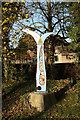
RBS waymark on route 64 at Skellingthorpe indicating 19 miles to Newark and 3½ miles to Lincoln
Image: © Richard Croft
Taken: 15 Nov 2011
0.24 miles
10

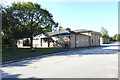
Community Centre and Youth Hall, Lincoln Road, Skellingthorpe
The Community Centre was opened in 1973 on the site of Skellingthorpe railway station that was opened in March 1897 by the Lancashire, Derbyshire and East Coast Railway on its (only) main line from Chesterfield to Lincoln. Absorbed by the Great Central in 1907 the station was closed by British Railways on 19th September 1955 although it carried freight until the line closed completely in February 1980 following a derailment, with the track being lifted in 1981. By 1964 the only buildings that remained were the goods shed, signal box and weigh-bridge office. The weigh-bridge office, used as a lamp room after 1964, appears to be the only remains of the station buildings and is now the Heritage Room.
Image: © Jo and Steve Turner
Taken: 29 Jan 2016
0.25 miles