IMAGES TAKEN NEAR TO
Oakfield Road, LINCOLN, LN6 5AA
Introduction
This page details the photographs taken nearby to Oakfield Road, LN6 5AA by members of the Geograph project.
The Geograph project started in 2005 with the aim of publishing, organising and preserving representative images for every square kilometre of Great Britain, Ireland and the Isle of Man.

There are currently over 7.5m images from over14,400 individuals and you can help contribute to the project by visiting https://www.geograph.org.uk
Image Map
Images are licensed for reuse under creativecommons.org/licenses/by-sa/2.0
Notes
- Clicking on the map will re-center to the selected point.
- The higher the marker number, the further away the image location is from the centre of the postcode.
Image Listing (38 Images Found)
Images are licensed for reuse under creativecommons.org/licenses/by-sa/2.0
Image
Details
Distance
1
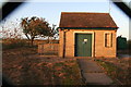
Anglian Water Pumping Station in Ferry Lane
Viewed through the mesh fence!
Image: © Chris
Taken: 27 Oct 2012
0.09 miles
2
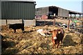
Manor farm cattle
Cattle at Manor Farm, Skellingthorpe
Image: © Richard Croft
Taken: 25 Mar 2007
0.11 miles
3
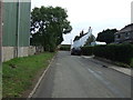
Lower Church Road, Skellingthorpe
Heading east.
Image: © JThomas
Taken: 14 Sep 2013
0.12 miles
4
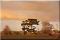
Skellingthorpe at dusk
Late afternoon low winter sun in Skellingthorpe, seen from NCN route 64
Image: © Richard Croft
Taken: 3 Dec 2014
0.15 miles
5

Skellingthorpe former estate cottages
A terrace of cottages built in 1878, with the date stone on one gable end and what looks like the Christ's Hospital coat of arms on the other. There is a nice version of this coat of arms above the door of the nearby Stone Arms pub.
These estate houses were built thanks to Henry Stone, Lord of the Manor of Skellingthorpe, who is buried in the churchyard.
Henry Stone died in 1693. In his will he gave his Manor and land to Christ's
Hospital, London. On the land they built cottages, a school and the pub.
In 1914 Christ's Hospital sold off by Auction all their properties in the Parish.
Opposite these cottages is a yard of cattle. The farm (Manor Farm) is a major producer, and there is a slaughterhouse at the end of nearby Ferry Lane.
I understand there are plans to build a housing estate on the site of the farm.
For more information on the features of Skellingthorpe and their historical significance, have a look at the Skellingthorpe Village Walk: http://www.n-kesteven.gov.uk/visitors/leisure/sports-and-leisure/countryside/countryside-walks/village-walks/skellingthorpe-village-walk/105918.article
Image: © Chris
Taken: 27 Oct 2012
0.15 miles
6

The war memorial at St Lawrence Church, Skellingthorpe
St Lawrence Church dates from 1855. The top parts of the nave were burnt in 1916 - see also https://www.geograph.org.uk/photo/5930594
Image: © Marathon
Taken: 29 Sep 2018
0.17 miles
7
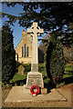
Skellingthorpe War Memorial
On Lower Church Road by St.Lawrence's church
Image: © Richard Croft
Taken: 30 Mar 2016
0.17 miles
8
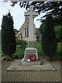
War Memorial, St Lawrence's Church, Skellingthorpe
Image: © JThomas
Taken: 14 Sep 2013
0.17 miles
9

St. Lawrence Church of England Primary School
The older part on the right was built at the same time as the church and designed by the same architects - Kendall and Pope 1855.
Image: © Jonathan Thacker
Taken: 12 Jan 2013
0.18 miles
10
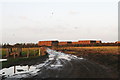
A wet autumn day in cattle country
Ferry Lane, with a cattle producer opposite this track and a slaughter house at the far end of the lane.
Grazing and a cattle (feed) crib on the left of the track and copious supply of straw in the distance.
Image: © Chris
Taken: 27 Oct 2012
0.18 miles