IMAGES TAKEN NEAR TO
Paving Way, LINCOLN, LN6 3QW
Introduction
This page details the photographs taken nearby to Paving Way, LN6 3QW by members of the Geograph project.
The Geograph project started in 2005 with the aim of publishing, organising and preserving representative images for every square kilometre of Great Britain, Ireland and the Isle of Man.

There are currently over 7.5m images from over14,400 individuals and you can help contribute to the project by visiting https://www.geograph.org.uk
Image Map
Images are licensed for reuse under creativecommons.org/licenses/by-sa/2.0
Notes
- Clicking on the map will re-center to the selected point.
- The higher the marker number, the further away the image location is from the centre of the postcode.
Image Listing (8 Images Found)
Images are licensed for reuse under creativecommons.org/licenses/by-sa/2.0
Image
Details
Distance
1
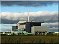
Energy plant, Whisby Road, Lincoln
An energy from waste plant operated by FCC Environment and Lincolnshire County Council.
Since this photo the area in the foreground has been taken over by a car showroom.
Image: © Stephen Richards
Taken: 14 Jun 2015
0.06 miles

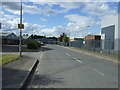
3

New development off Whisby Road
This whole area south of Whisby Road and west of the by-pass is being developed as an industrial area.
Image: © Jonathan Thacker
Taken: 6 Feb 2013
0.15 miles

5
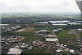
Whisby Road Industrial Estate, Lincoln: aerial 2016
Image: © Chris
Taken: 24 Jun 2016
0.22 miles
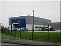
7

Landfill site to the south of Whisby Road
The area was formerly a collection of sand and gravel pits.
Image: © Jonathan Thacker
Taken: 6 Feb 2013
0.24 miles