IMAGES TAKEN NEAR TO
Abingdon Avenue, LINCOLN, LN6 3LE
Introduction
This page details the photographs taken nearby to Abingdon Avenue, LN6 3LE by members of the Geograph project.
The Geograph project started in 2005 with the aim of publishing, organising and preserving representative images for every square kilometre of Great Britain, Ireland and the Isle of Man.

There are currently over 7.5m images from over14,400 individuals and you can help contribute to the project by visiting https://www.geograph.org.uk
Image Map
Images are licensed for reuse under creativecommons.org/licenses/by-sa/2.0
Notes
- Clicking on the map will re-center to the selected point.
- The higher the marker number, the further away the image location is from the centre of the postcode.
Image Listing (6 Images Found)
Images are licensed for reuse under creativecommons.org/licenses/by-sa/2.0
Image
Details
Distance
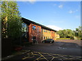
1

The Regatta, Henley Way
Houses offices amongst other uses the Crown Prosecution Service. Designed by XL Architects http://www.xlarchitects.co.uk/projects/view/The-Regatta-Doddington-Road-Lincoln/
Image: © Jonathan Thacker
Taken: 25 Apr 2019
0.16 miles
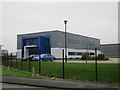
2
Offices on Doddington Road
Seen from the rear on Henley way.
Image: © Jonathan Thacker
Taken: 25 Apr 2019
0.17 miles

4

Doddington Road
Seen from the end of Pershore way.
Image: © Jonathan Thacker
Taken: 25 Apr 2019
0.24 miles
6
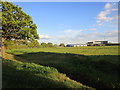
Vacant land on Doddington Road
Awaiting development as offices/industry.
Image: © Jonathan Thacker
Taken: 25 Apr 2019
0.24 miles