IMAGES TAKEN NEAR TO
Denby Dale Close, LINCOLN, LN6 0XL
Introduction
This page details the photographs taken nearby to Denby Dale Close, LN6 0XL by members of the Geograph project.
The Geograph project started in 2005 with the aim of publishing, organising and preserving representative images for every square kilometre of Great Britain, Ireland and the Isle of Man.

There are currently over 7.5m images from over14,400 individuals and you can help contribute to the project by visiting https://www.geograph.org.uk
Image Map (Loading...)


Getting Data...Please wait
Leaflet Map data © OpenStreetMap
Images are licensed for reuse under creativecommons.org/licenses/by-sa/2.0
Notes
- Clicking on the map will re-center to the selected point.
- The higher the marker number, the further away the image location is from the centre of the postcode.
Image Listing (8 Images Found)
Images are licensed for reuse under creativecommons.org/licenses/by-sa/2.0
Image
Details
Distance

2
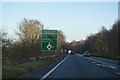
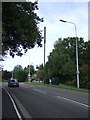
A46, approaching Skellingthorpe Roundabout
Image: © N Chadwick
Taken: 27 Dec 2016
0.08 miles
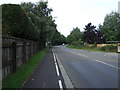
3

A46, approaching Skellingthorpe Roundabout
Image: © N Chadwick
Taken: 27 Dec 2016
0.10 miles
4
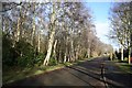
Cross Holts
Silver Birch trees on Malham Drive on a sunny January morning
Image: © Richard Croft
Taken: 21 Jan 2007
0.13 miles
5
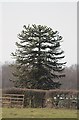
Monkey Puzzle Tree at Daisy Made Farm
Image: © J.Hannan-Briggs
Taken: 7 Apr 2013
0.20 miles
8
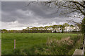
Rainclouds over Skellingthorpe Moor
Towards Wiseholme Holt.
Image: © Julian P Guffogg
Taken: 24 Apr 2017
0.24 miles