IMAGES TAKEN NEAR TO
Skellingthorpe Road, LINCOLN, LN6 0EN
Introduction
This page details the photographs taken nearby to Skellingthorpe Road, LN6 0EN by members of the Geograph project.
The Geograph project started in 2005 with the aim of publishing, organising and preserving representative images for every square kilometre of Great Britain, Ireland and the Isle of Man.

There are currently over 7.5m images from over14,400 individuals and you can help contribute to the project by visiting https://www.geograph.org.uk
Image Map (Loading...)


Getting Data...Please wait
Leaflet Map data © OpenStreetMap
Images are licensed for reuse under creativecommons.org/licenses/by-sa/2.0
Notes
- Clicking on the map will re-center to the selected point.
- The higher the marker number, the further away the image location is from the centre of the postcode.
Image Listing (14 Images Found)
Images are licensed for reuse under creativecommons.org/licenses/by-sa/2.0
Image
Details
Distance
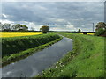
2
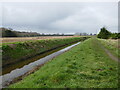
Footpath alongside Catchwater Drain
Image: © Jonathan Thacker
Taken: 6 Mar 2024
0.08 miles
3
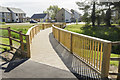
Recently completed footbridge
A boardwalk over a natural wet area and retention basin at a new housing development.
Image: © Julian P Guffogg
Taken: 4 May 2017
0.12 miles
4
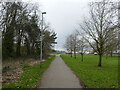
Footpath off Hunt Lea Avenue, Lincoln
Image: © Jonathan Thacker
Taken: 6 Mar 2024
0.13 miles
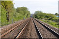
5
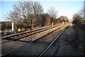
Pedestrian rail crossing
Footpath crossing the railway near Oak Farm
Image: © Richard Croft
Taken: 18 Jan 2009
0.13 miles
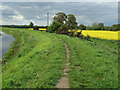
6
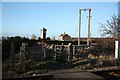
Kissing Gate
Footpath & kissing gate at the pedestrian railway crossing near Oak Farm
Image: © Richard Croft
Taken: 18 Jan 2009
0.14 miles
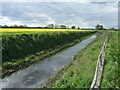
7
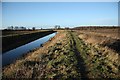
Catchwater Drain
View west near Oak Farm
Image: © Richard Croft
Taken: 18 Jan 2009
0.18 miles