IMAGES TAKEN NEAR TO
Hemswell Avenue, LINCOLN, LN6 0BA
Introduction
This page details the photographs taken nearby to Hemswell Avenue, LN6 0BA by members of the Geograph project.
The Geograph project started in 2005 with the aim of publishing, organising and preserving representative images for every square kilometre of Great Britain, Ireland and the Isle of Man.

There are currently over 7.5m images from over14,400 individuals and you can help contribute to the project by visiting https://www.geograph.org.uk
Image Map (Loading...)


Getting Data...Please wait
Leaflet Map data © OpenStreetMap
Images are licensed for reuse under creativecommons.org/licenses/by-sa/2.0
Notes
- Clicking on the map will re-center to the selected point.
- The higher the marker number, the further away the image location is from the centre of the postcode.
Image Listing (10 Images Found)
Images are licensed for reuse under creativecommons.org/licenses/by-sa/2.0
Image
Details
Distance
2
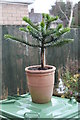
Young (wet) Monkey Puzzle Tree
Not yet planted out.
Image: © J.Hannan-Briggs
Taken: 1 Jan 2014
0.21 miles
5

Starmers Pit
Fishing pond formed from old aggregate workings near Sainsbury's supermarket
Image: © Richard Croft
Taken: 12 Aug 2009
0.22 miles

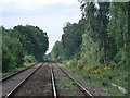
8
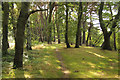
Woodland by Starmers Pit
Woodland between Starmers Pit and Tritton Road
Image: © Richard Croft
Taken: 28 Sep 2013
0.23 miles
9
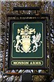
The sign of the Monson Arms
Pub sign for the Monson Arms http://www.geograph.org.uk/photo/1104498
Image: © Richard Croft
Taken: 3 Jan 2009
0.24 miles
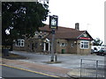
10
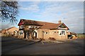
Monson Arms
Pub on Skellingthorpe Road
Image: © Richard Croft
Taken: 3 Jan 2009
0.24 miles