IMAGES TAKEN NEAR TO
Old Brick Kiln Lane, LINCOLN, LN5 9XP
Introduction
This page details the photographs taken nearby to Old Brick Kiln Lane, LN5 9XP by members of the Geograph project.
The Geograph project started in 2005 with the aim of publishing, organising and preserving representative images for every square kilometre of Great Britain, Ireland and the Isle of Man.

There are currently over 7.5m images from over14,400 individuals and you can help contribute to the project by visiting https://www.geograph.org.uk
Image Map
Images are licensed for reuse under creativecommons.org/licenses/by-sa/2.0
Notes
- Clicking on the map will re-center to the selected point.
- The higher the marker number, the further away the image location is from the centre of the postcode.
Image Listing (8 Images Found)
Images are licensed for reuse under creativecommons.org/licenses/by-sa/2.0
Image
Details
Distance
1
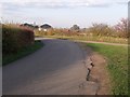
Junction of Old Brick Kiln Lane and Queen Headland Lane
Image: © J.Hannan-Briggs
Taken: 19 Nov 2011
0.13 miles
2
View towards new farm buildings on Old Brickkiln Lane
Taken from Torgate Lane.
Image: © Jonathan Thacker
Taken: 23 Jun 2012
0.16 miles
3
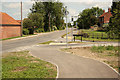
Bassingham cycle route
New cycle route between Bassingham and Carlton-le-Moorland at the junction of Old Brickkiln Lane and Carlton Road
Image: © Richard Croft
Taken: 14 Jun 2012
0.19 miles
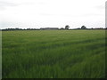
5
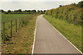
Cycle route to Carlton-le-Moorland
New cycle route connecting Carlton-le-Moorland and Bassingham
Image: © Richard Croft
Taken: 14 Jun 2012
0.21 miles
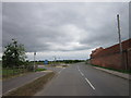
6
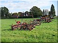
Farm machinery by Carlton Road, Bassingham
Houses on Torgate Lane can be seen on the far side of the field.
Image: © Oliver Dixon
Taken: 12 Oct 2012
0.25 miles
7
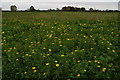
Yellow flowered field margin by Queen Headland Lane, Carlton le Moorland
Image: © Chris
Taken: 23 Oct 2015
0.25 miles
8
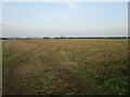
Stubble field off Old Brickkiln Lane
On a misty day.
Image: © Jonathan Thacker
Taken: 7 Nov 2020
0.25 miles