IMAGES TAKEN NEAR TO
Larne Road, LINCOLN, LN5 9TP
Introduction
This page details the photographs taken nearby to Larne Road, LN5 9TP by members of the Geograph project.
The Geograph project started in 2005 with the aim of publishing, organising and preserving representative images for every square kilometre of Great Britain, Ireland and the Isle of Man.

There are currently over 7.5m images from over14,400 individuals and you can help contribute to the project by visiting https://www.geograph.org.uk
Image Map
Images are licensed for reuse under creativecommons.org/licenses/by-sa/2.0
Notes
- Clicking on the map will re-center to the selected point.
- The higher the marker number, the further away the image location is from the centre of the postcode.
Image Listing (6 Images Found)
Images are licensed for reuse under creativecommons.org/licenses/by-sa/2.0
Image
Details
Distance
1
Pond at North Hykeham
Viewed from the Viking Way in the adjacent square.
Image: © Ian Paterson
Taken: 28 Dec 2008
0.09 miles
2
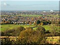
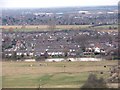
Bracebridge Low Fields from Lincoln Cliff
Taken on the Viking Way, just outside Bracebridge Heath. The strip of housing across the centre is Bracebridge/Bracebridge Low Fields, and North Hykeham in the distance. Between the two areas is the River Witham and its surrounding basin.
Image: © Oliver Mills
Taken: 4 Nov 2020
0.17 miles
3
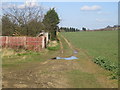
Path of the disused Lincoln-Grantham railway
This track at the east side of Brant Road is all that remains of the Lincoln to Grantham railway.
Image: © Matthew Smith
Taken: 13 Mar 2007
0.19 miles