IMAGES TAKEN NEAR TO
Station Road, LINCOLN, LN5 9SU
Introduction
This page details the photographs taken nearby to Station Road, LN5 9SU by members of the Geograph project.
The Geograph project started in 2005 with the aim of publishing, organising and preserving representative images for every square kilometre of Great Britain, Ireland and the Isle of Man.

There are currently over 7.5m images from over14,400 individuals and you can help contribute to the project by visiting https://www.geograph.org.uk
Image Map
Images are licensed for reuse under creativecommons.org/licenses/by-sa/2.0
Notes
- Clicking on the map will re-center to the selected point.
- The higher the marker number, the further away the image location is from the centre of the postcode.
Image Listing (15 Images Found)
Images are licensed for reuse under creativecommons.org/licenses/by-sa/2.0
Image
Details
Distance
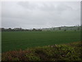
1
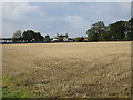
Stubble field and the old station, Harmston
The station site is now used for the storage of caravans.
Image: © Jonathan Thacker
Taken: 14 Oct 2016
0.01 miles
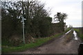
2
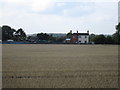
The old station Harmston
Much altered but still recognisable as a former Great Northern Railway Station. The station opened in 1867 and closed in 1962.
Image: © Jonathan Thacker
Taken: 14 Oct 2016
0.01 miles
3
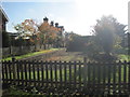
Harmston railway station (site), Lincolnshire
Opened in 1867 by the Great Northern Railway on the line from Honington to Lincoln, this station closed to passengers in 1962.
View south towards Navenby and Honington, on one of those days when the sun was just in the wrong place! As with other former stations on the line, it is now a private residence.
Image: © Nigel Thompson
Taken: 11 Nov 2012
0.01 miles
4
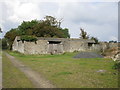
Disused farm building by Bottom Park, Harmston
Look to have been built as cow sheds.
Image: © Jonathan Thacker
Taken: 14 Oct 2016
0.11 miles
5
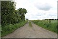
Track and footpath off Station Road
Near Harmston.
Image: © J.Hannan-Briggs
Taken: 16 May 2012
0.11 miles
6
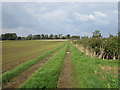
Footpath to Station Road
This section is also a well used farm track.
Image: © Jonathan Thacker
Taken: 14 Oct 2016
0.13 miles
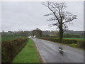
10
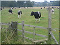
Footpath: Broughton Lane to Harmston
The footpath runs across this field in the grounds of Harmston Hall. Could it be the bulls have been placed in this field to deter people from coming too close to the house.
Image: © Matthew Smith
Taken: 15 Aug 2006
0.17 miles