IMAGES TAKEN NEAR TO
Bancroft Close, LINCOLN, LN5 9SQ
Introduction
This page details the photographs taken nearby to Bancroft Close, LN5 9SQ by members of the Geograph project.
The Geograph project started in 2005 with the aim of publishing, organising and preserving representative images for every square kilometre of Great Britain, Ireland and the Isle of Man.

There are currently over 7.5m images from over14,400 individuals and you can help contribute to the project by visiting https://www.geograph.org.uk
Image Map
Images are licensed for reuse under creativecommons.org/licenses/by-sa/2.0
Notes
- Clicking on the map will re-center to the selected point.
- The higher the marker number, the further away the image location is from the centre of the postcode.
Image Listing (26 Images Found)
Images are licensed for reuse under creativecommons.org/licenses/by-sa/2.0
Image
Details
Distance
1
Grantham Road, Waddington
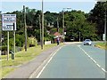
Buildings in Waddington are noticeably different from the traditional ancient limestone common in all the other villages nearby. Much of it was built during and after WWII, partly to serve the large RAF base there, and partly to replace buildings damaged in enemy raids targeting the airfield. The airfield itself played a large role as a bomber base during WWII, and more recently as a V-bomber base, but is now the home of AWACS early warning planes
Image: © David Dixon
Taken: 5 Aug 2014
0.11 miles
2
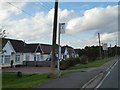
Bus stop outside bungalows in Waddington, by A607
Image: © David Smith
Taken: 18 Sep 2018
0.13 miles
3
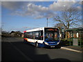
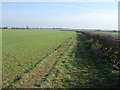
Bus on Millers Road, Waddington
A bus waits on Millers Road in Waddington before returning to Lincoln city centre via Brant Road. A more direct service to the city is provided by route 1, which is the main route between Lincoln and Grantham.
Image: © Richard Vince
Taken: 3 Mar 2012
0.15 miles
4
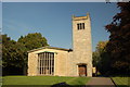
St Michael's Church, Waddington, Lincolnshire
The parish church of St Michael in Waddington. Built in 1952-4 by R. Corless to replace the original church that was destroyed in the second world war
Image: © Gary Brothwell
Taken: 1 Sep 2010
0.16 miles
5
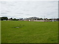
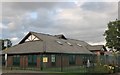
Waddington Village Hall and Recreation Ground
Image: © Jonathan Thacker
Taken: 21 Jul 2024
0.19 miles
8
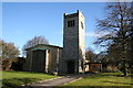
St.Michael's church, Waddington, Lincs.
The medieval church was destroyed during the second world war - apparently by a stray German bomb intended for RAF Waddington. The new church built 1952-4 by R.Corless of Skipper & Corless of Lowestoft has all the essential components .... nave, chancel, west tower, big windows, but not the soul of its predecessor.
Image: © Richard Croft
Taken: 9 Feb 2006
0.20 miles
10
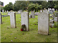
Vulcan crash graves
These graves in St. Michael's churchyard are those of the 3 rear seat crew of the Avro Vulcan that crashed at London Heathrow on 10 October 1956 on its return from Australia. The 2 pilots ejected safely.
Image: © Peter Langsdale
Taken: 16 Sep 2002
0.21 miles