IMAGES TAKEN NEAR TO
Grantham Road, LINCOLN, LN5 9SJ
Introduction
This page details the photographs taken nearby to Grantham Road, LN5 9SJ by members of the Geograph project.
The Geograph project started in 2005 with the aim of publishing, organising and preserving representative images for every square kilometre of Great Britain, Ireland and the Isle of Man.

There are currently over 7.5m images from over14,400 individuals and you can help contribute to the project by visiting https://www.geograph.org.uk
Image Map
Images are licensed for reuse under creativecommons.org/licenses/by-sa/2.0
Notes
- Clicking on the map will re-center to the selected point.
- The higher the marker number, the further away the image location is from the centre of the postcode.
Image Listing (13 Images Found)
Images are licensed for reuse under creativecommons.org/licenses/by-sa/2.0
Image
Details
Distance
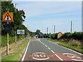
5
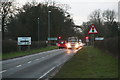
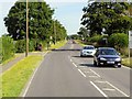
Junction of the A607 Grantham Road and the B1178 at Harmston
Image: © Chris
Taken: 10 Jan 2014
0.16 miles
7
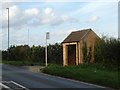
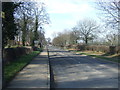
Bus shelter on A607 east of Harmston
As Harmston is not on the main A607, this shelter serves the village. It is close to crossroads with a link to the village
Image: © David Smith
Taken: 18 Sep 2018
0.19 miles
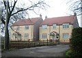
9
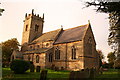
All Saints' church, Harmston, Lincs.
A grand Norman tower with a Perpendicular top and a church of 1868 by R.J.Withers
Image: © Richard Croft
Taken: 31 Oct 2005
0.23 miles
10
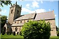
All Saints' church
Church of 1868 by R.J.Withers with a genuine Norman tower
Image: © Richard Croft
Taken: 9 Jun 2008
0.24 miles