IMAGES TAKEN NEAR TO
Timms Lane, LINCOLN, LN5 9RQ
Introduction
This page details the photographs taken nearby to Timms Lane, LN5 9RQ by members of the Geograph project.
The Geograph project started in 2005 with the aim of publishing, organising and preserving representative images for every square kilometre of Great Britain, Ireland and the Isle of Man.

There are currently over 7.5m images from over14,400 individuals and you can help contribute to the project by visiting https://www.geograph.org.uk
Image Map
Images are licensed for reuse under creativecommons.org/licenses/by-sa/2.0
Notes
- Clicking on the map will re-center to the selected point.
- The higher the marker number, the further away the image location is from the centre of the postcode.
Image Listing (27 Images Found)
Images are licensed for reuse under creativecommons.org/licenses/by-sa/2.0
Image
Details
Distance
1
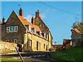
Manor Lane, Waddington
Taken from Hill Top. A telegraph pole with the old-style cross-arms is visible at the end of the road.
Image: © Oliver Mills
Taken: 4 Nov 2020
0.04 miles
2
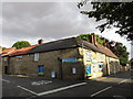
Waddington Old Village Store
Most of the shops in Waddington are at the east end of Bar Lane. This one is at the other end of the street closer to the original village centre.
Image: © Jonathan Thacker
Taken: 11 Aug 2015
0.06 miles
3
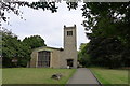
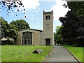
Church of St Michael, Waddington
An unexpectedly modern church for an ancient village. The reason is made clear by the foundation stone, which reads: “The medieval church was destroyed by enemy action on 9th May 1941. This stone was laid by Maurice Bishop of Lincoln on 29th September 1952”. The air raid was targeting the important RAF station adjoining the village
Image: © Tim Heaton
Taken: 23 Aug 2013
0.08 miles
4
St Michael's Church, Waddington
Modern building, consecrated in 1954, it replaces an older church which was destroyed by bombing in 1941
Image: © J.Hannan-Briggs
Taken: 10 Jul 2011
0.09 miles
5
St. Michael's church Waddington
The churchyard contains 33 War Graves which can be seen here http://media.geograph.org.uk/files/fe9fc289c3ff0af142b6d3bead98a923/Waddington_War_Graves.pdf
Image: © Adrian S Pye
Taken: 7 Jun 2017
0.09 miles
6
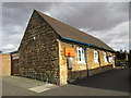
Waddington Community Hub and Parish Office
The place to go for help and information.
Image: © Jonathan Thacker
Taken: 11 Aug 2015
0.09 miles
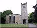
7
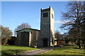
St.Michael's church, Waddington, Lincs.
The medieval church was destroyed during the second world war - apparently by a stray German bomb intended for RAF Waddington. The new church built 1952-4 by R.Corless of Skipper & Corless of Lowestoft has all the essential components .... nave, chancel, west tower, big windows, but not the soul of its predecessor.
Image: © Richard Croft
Taken: 9 Feb 2006
0.12 miles
8

Waddington's memorial clock
In memory of RAAF 363 and 367 squadrons referred to here https://www.geograph.org.uk/photo/6260673
Image: © Adrian S Pye
Taken: 8 Sep 2019
0.12 miles
9

RAF Waddington memorial
Relates to both wars and all personnel who lost their lives while serving at RAF Waddington.
Image: © Adrian S Pye
Taken: 8 Sep 2019
0.13 miles
10

Part of the WW2 memorial at Waddington
The clock which is in memory of Royal Australian Air Force squadrons 363 and 367 can be seen here geograph.org.uk/photo/4609369 and https://www.geograph.org.uk/photo/6260681
Image: © Adrian S Pye
Taken: 8 Sep 2019
0.13 miles