IMAGES TAKEN NEAR TO
Brocklebank Close, LINCOLN, LN5 9LJ
Introduction
This page details the photographs taken nearby to Brocklebank Close, LN5 9LJ by members of the Geograph project.
The Geograph project started in 2005 with the aim of publishing, organising and preserving representative images for every square kilometre of Great Britain, Ireland and the Isle of Man.

There are currently over 7.5m images from over14,400 individuals and you can help contribute to the project by visiting https://www.geograph.org.uk
Image Map
Images are licensed for reuse under creativecommons.org/licenses/by-sa/2.0
Notes
- Clicking on the map will re-center to the selected point.
- The higher the marker number, the further away the image location is from the centre of the postcode.
Image Listing (33 Images Found)
Images are licensed for reuse under creativecommons.org/licenses/by-sa/2.0
Image
Details
Distance
1
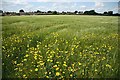
Bassingham barley
Barley off Torgate Lane near Bassingham
Image: © Richard Croft
Taken: 4 Jul 2009
0.10 miles
2
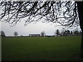
Bassingham Playing Field
Situated in the south east corner of the village. The new medical practice can be seen in the distance.
Image: © Matthew Smith
Taken: 12 Mar 2006
0.13 miles
3

Tortoiseshell butterfly
Butterfly in the barley off Torgate Lane http://www.geograph.org.uk/photo/1386945
Image: © Richard Croft
Taken: 4 Jul 2009
0.15 miles
4

The sign of the Five Bells
Pub sign in Bassingham
Image: © Richard Croft
Taken: 4 Jul 2009
0.17 miles
5
Mosaics, Bassingham Primary School
These mosaics are just four of a number which adorn the entrance to Bassingham Primary School. From the school entrance, a newly opened cycleway runs beside the road between Bassingham and Carlton-le-Moorland.
Image: © Oliver Dixon
Taken: 12 Oct 2012
0.17 miles
6
Mosaics, Bassingham
These mosaics are just three of a number which adorn the entrance to Bassingham Primary School. The mosaic of the bicycle somewhat resembles an old-fashioned Boneshaker.
Image: © Oliver Dixon
Taken: 12 Oct 2012
0.18 miles
7
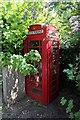
K6 Telephone Box, High Street, Bassingham
Grade II Listed K6 box. The K6 was designed by Giles Gilbert Scott in 1935 for the General Post Office on the occasion of King George V's Silver Jubilee. The kiosk stands on the High Street outside an old wooden telephone exchange building.
Image: © Jo and Steve Turner
Taken: 13 May 2024
0.18 miles
8
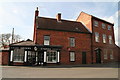
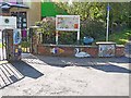
Green's Stores and The Tall House, Bassingham
Image: © Chris
Taken: 11 Apr 2015
0.18 miles
9
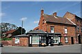
Greens of Bassingham, 26 High Street, Bassingham
Grade II Listed early 18th century house. The 19th century shop front was built across original house and extension. The shops website states it was built in the 1720s and was called 'Morsheds' (sic) from 1866 to 1945 when it changed to 'Greens'. However, when I search the directories, no Morshead is listed before or in 1896. In the 1905 directory the listing gives 'Morshead John, milliner, draper, boot & shoe dealer, grocer, provision merchant, baker, confectioner, flour & offal dealer & insurance agent, Post office.' The website also tells us it became the Post Office in 1849 and remains so today, except for a few years prior to 2013. A search of directories gives the following details for the Post Office; 1856-1872 Robert Boole; 1885 Post, Money Order & Telegraph Office & Savings Bank Robert Boole; 1896 Post, Money Order & Telegraph Office & Savings Bank John Enderby. No address is given for them however. Robert Green was a Shop Assistant in Morshead’s and started to rent it in 1934 before purchasing it in 1945. The Green's stopped running the shop in 1972.
Image: © Jo and Steve Turner
Taken: 13 May 2024
0.18 miles
10
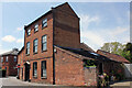
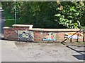
The Tall House, 24 High Street, Bassingham
Grade II Listed late 18th century house. Dated about 1790 and probably built by the owners of what is now Green's stores as their own accommodation.
Image: © Jo and Steve Turner
Taken: 13 May 2024
0.18 miles