IMAGES TAKEN NEAR TO
Navenby Lane, LINCOLN, LN5 9JF
Introduction
This page details the photographs taken nearby to Navenby Lane, LN5 9JF by members of the Geograph project.
The Geograph project started in 2005 with the aim of publishing, organising and preserving representative images for every square kilometre of Great Britain, Ireland and the Isle of Man.

There are currently over 7.5m images from over14,400 individuals and you can help contribute to the project by visiting https://www.geograph.org.uk
Image Map
Images are licensed for reuse under creativecommons.org/licenses/by-sa/2.0
Notes
- Clicking on the map will re-center to the selected point.
- The higher the marker number, the further away the image location is from the centre of the postcode.
Image Listing (9 Images Found)
Images are licensed for reuse under creativecommons.org/licenses/by-sa/2.0
Image
Details
Distance
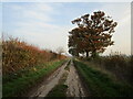
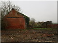
3

Tin shed
Derelict corrugated iron farm building behind an impenetrable thicket of briar on Navenby Lane
Image: © Richard Croft
Taken: 11 Mar 2010
0.19 miles
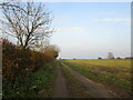
5
Old Brickkiln Lane, Bassingham Fen
Old Brickkiln Lane at the junction with Navenby Lane.
Image: © Matthew Smith
Taken: 19 Mar 2006
0.20 miles
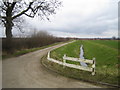
6
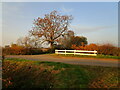
Junction of Navenby Lane and Old Brickkiln Lane
Navenby Lane crosses the picture. West Brant Syke is culverted beneath it.
Image: © Jonathan Thacker
Taken: 7 Nov 2020
0.21 miles
7
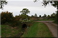
West Brant Syke under Navenby Lane, by Brickkiln Lane
Image: © Chris
Taken: 23 Oct 2015
0.21 miles
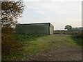
9
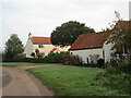
Workhouse Cottage, Bassingham
This was the site of Bassingham's Workhouse as marked on 1906 edition of OS 6" map.
Image: © Jonathan Thacker
Taken: 7 Nov 2020
0.25 miles