IMAGES TAKEN NEAR TO
Moorland Close, LINCOLN, LN5 9GL
Introduction
This page details the photographs taken nearby to Moorland Close, LN5 9GL by members of the Geograph project.
The Geograph project started in 2005 with the aim of publishing, organising and preserving representative images for every square kilometre of Great Britain, Ireland and the Isle of Man.

There are currently over 7.5m images from over14,400 individuals and you can help contribute to the project by visiting https://www.geograph.org.uk
Image Map
Images are licensed for reuse under creativecommons.org/licenses/by-sa/2.0
Notes
- Clicking on the map will re-center to the selected point.
- The higher the marker number, the further away the image location is from the centre of the postcode.
Image Listing (38 Images Found)
Images are licensed for reuse under creativecommons.org/licenses/by-sa/2.0
Image
Details
Distance
1
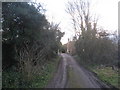
The end of Manor Lane
Proposed new housing developments will soon change this view.
Image: © Jonathan Thacker
Taken: 14 Feb 2011
0.03 miles
2
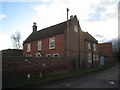
The Old Manor, Carlton le Moorland
Image: © Jonathan Thacker
Taken: 14 Feb 2011
0.08 miles
3
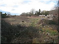
Site for development
The financial crisis has doubtless caused delay to the development of this site for housing.
Image: © Jonathan Thacker
Taken: 14 Feb 2011
0.08 miles
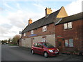
4
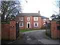
The Manor, Carlton le Moorland
Late Georgian.
Image: © Jonathan Thacker
Taken: 14 Feb 2011
0.09 miles
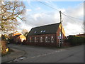
5
Another former Chapel in Carlton le Moorland
Image: © Jonathan Thacker
Taken: 14 Feb 2011
0.12 miles
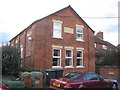
6
Former School, Carlton le Moorland
Most children of primary school age now go to the school in Bassingham. Though the distance is short because of the state of the linking road the Carlton le Moorland and Bassingham Pathway Group was set up to provide a safe walking/cycling route between the two villages http://parishes.lincolnshire.gov.uk/CarltonleMoorland/section.asp?catId=32662
Image: © Jonathan Thacker
Taken: 14 Feb 2011
0.12 miles
7
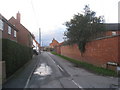
Brewery Lane, Carlton le Moorland
Like most of the village a mixture of new developments, old cottages, high walls and suburban hedges.
Image: © Jonathan Thacker
Taken: 14 Feb 2011
0.13 miles
8
The White Hart, Carlton le Moorland
Incorporates extensive areas of limestone walling. Unusual here but normal only a few miles to the east.
Image: © Jonathan Thacker
Taken: 14 Feb 2011
0.14 miles
9
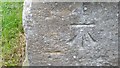
Ordnance Survey Cut Mark
This OS cut mark can be found on the west face of St Mary's Church. It marks a point 15.905m above mean sea level.
Image: © Adrian Dust
Taken: 21 Jul 2017
0.14 miles
10
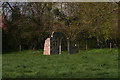
A ruin or a folly in a paddock off Bridle Lane, Carlton le Moorland
Image: © Chris
Taken: 9 Apr 2016
0.15 miles