IMAGES TAKEN NEAR TO
Sky Lane, LINCOLN, LN5 9FL
Introduction
This page details the photographs taken nearby to Sky Lane, LN5 9FL by members of the Geograph project.
The Geograph project started in 2005 with the aim of publishing, organising and preserving representative images for every square kilometre of Great Britain, Ireland and the Isle of Man.

There are currently over 7.5m images from over14,400 individuals and you can help contribute to the project by visiting https://www.geograph.org.uk
Image Map
Images are licensed for reuse under creativecommons.org/licenses/by-sa/2.0
Notes
- Clicking on the map will re-center to the selected point.
- The higher the marker number, the further away the image location is from the centre of the postcode.
Image Listing (14 Images Found)
Images are licensed for reuse under creativecommons.org/licenses/by-sa/2.0
Image
Details
Distance
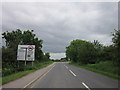
1
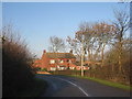
House on Sky Lane, Haddington
This lane is now a cul-de-sac but once was the road from Haddington to Thorpe on the Hill before the A46 was turned into a dual carriageway.
Image: © Jonathan Thacker
Taken: 11 Dec 2012
0.02 miles
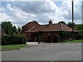
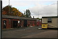
3
Sky Barn Lane
Cottages on Sky Barn Lane near Thorpe-on-the-Hill
Image: © Richard Croft
Taken: 28 Mar 2007
0.05 miles
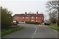
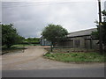
4
Cul-de-sac of Sky Barn Lane north of Haddington
Image: © Chris
Taken: 22 Oct 2016
0.06 miles

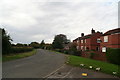
6
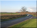
Haddington Lane
Diverted from its original course when the A46 was turned into a dual carriageway.
Image: © Jonathan Thacker
Taken: 11 Dec 2012
0.09 miles
10
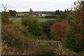
Path down the bank towards the A46 south of Thorpe on the Hill
Image: © Chris
Taken: 22 Oct 2016
0.22 miles