IMAGES TAKEN NEAR TO
Bridge Road, LINCOLN, LN5 9FD
Introduction
This page details the photographs taken nearby to Bridge Road, LN5 9FD by members of the Geograph project.
The Geograph project started in 2005 with the aim of publishing, organising and preserving representative images for every square kilometre of Great Britain, Ireland and the Isle of Man.

There are currently over 7.5m images from over14,400 individuals and you can help contribute to the project by visiting https://www.geograph.org.uk
Image Map
Images are licensed for reuse under creativecommons.org/licenses/by-sa/2.0
Notes
- Clicking on the map will re-center to the selected point.
- The higher the marker number, the further away the image location is from the centre of the postcode.
Image Listing (37 Images Found)
Images are licensed for reuse under creativecommons.org/licenses/by-sa/2.0
Image
Details
Distance
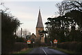
2
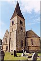
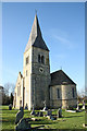
Aubourn Church
This was the new Victorian church of St Peter, which was built between Aubourn and Haddington in 1861-1862. However, the church was not as robust as the old and became unsafe after a period of deterioration. The old church, which at first was used as a mortuary chapel and then had restoration work carried out in 1933, was reinstated as the Parish Church.
This new church was closed 14-May-1968 and partly demolished on 26-Oct-1973, leaving the remains as a monument. The spire was re-shingled in 2005.
Image: © Jo and Steve Turner
Taken: Unknown
0.07 miles
3
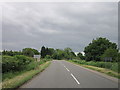
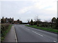
Entering Aubourn from the west
For history of Aubourn see: http://parishes.lincolnshire.gov.uk/AubournandHaddington/section.asp?docId=99638
Image: © Chris
Taken: 10 Jan 2014
0.08 miles
4
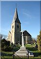
Aubourn War Memorial
War Memorial by the Clock Tower
Image: © Richard Croft
Taken: 30 Jan 2010
0.08 miles
5
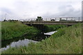
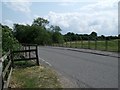
Bridge over the River Witham, Haddington
Carrying Bridge Road
Image: © Tim Heaton
Taken: 20 Jul 2014
0.08 miles
6
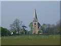
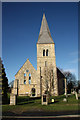
Clock Tower
Aubourn clock tower http://www.geograph.org.uk/photo/1694385 The 'new' St. Peter's parish church was built 1861-3 by John H Hakewill, but fell into disrepair in the 1960s. The nave and transepts were demolished in 1974 with the tower and east facing clock, given in memory of Camilla Hopkinson of Malborough Farm, retained. A Heritage Lottery Fund grant in 2004 paid for the tower to be restored and maintained as Aubourn Clock Tower, managed by Aubourn & Haddington Parish Council.
Image: © Richard Croft
Taken: 22 Apr 2011
0.08 miles
7
Aubourn clock tower
The 'new' St. Peter's parish church was built 1861-3 by John H Hakewill, but fell into disrepair in the 1960s. The nave and transepts were demolished in 1974 with the tower and east facing clock, given in memory of Camilla Hopkinson of Malborough Farm, retained. A Heritage Lottery Fund grant in 2004 has allowed the tower to be restored and maintained as Aubourn Clock Tower, managed by Aubourn & Haddington Parish Council http://www.aubourn-haddington.org.uk/
Image: © Richard Croft
Taken: 30 Jan 2010
0.08 miles
8
Aubourn clock tower
The 'new' St. Peter's parish church was built 1861-3 by John H Hakewill, but fell into disrepair in the 1960s. The nave and transepts were demolished in 1974 with the tower and east facing clock, given in memory of Camilla Hopkinson of Malborough Farm, retained. A Heritage Lottery Fund grant in 2004 has allowed the tower to be restored and maintained as Aubourn Clock Tower, managed by Aubourn & Haddington Parish Council http://www.aubourn-haddington.org.uk/
Image: © Richard Croft
Taken: 30 Jan 2010
0.08 miles