IMAGES TAKEN NEAR TO
Moor Lane, LINCOLN, LN5 9FA
Introduction
This page details the photographs taken nearby to Moor Lane, LN5 9FA by members of the Geograph project.
The Geograph project started in 2005 with the aim of publishing, organising and preserving representative images for every square kilometre of Great Britain, Ireland and the Isle of Man.

There are currently over 7.5m images from over14,400 individuals and you can help contribute to the project by visiting https://www.geograph.org.uk
Image Map
Images are licensed for reuse under creativecommons.org/licenses/by-sa/2.0
Notes
- Clicking on the map will re-center to the selected point.
- The higher the marker number, the further away the image location is from the centre of the postcode.
Image Listing (27 Images Found)
Images are licensed for reuse under creativecommons.org/licenses/by-sa/2.0
Image
Details
Distance
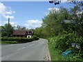
2
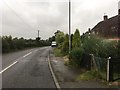
Thurlby: junction of Moor Lane and Bassingham Road
Image: © Chris
Taken: 10 Jan 2014
0.03 miles
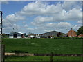
5
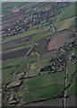
River Witham from Thurlby to Bassingham: aerial 2017
Image: © Chris
Taken: 25 Mar 2017
0.15 miles
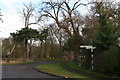
7
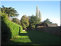
The approach to St. Germain's church
On a cold, bright, late autumn day.
Image: © Jonathan Thacker
Taken: 4 Nov 2013
0.19 miles
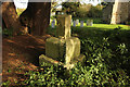
9
Remains of the churchyard cross, Thurlby
Medieval but of indeterminate age https://historicengland.org.uk/listing/the-list/list-entry/1013082?section=official-list-entry
Image: © Jonathan Thacker
Taken: 3 Aug 2023
0.20 miles
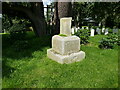
10
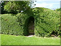
Churchyard cross
Scheduled Ancient Monument, base and part of the shaft of a medieval cross in St.Germain's churchyard
Image: © Richard Croft
Taken: 28 Oct 2014
0.20 miles