IMAGES TAKEN NEAR TO
Haddington, LINCOLN, LN5 9EF
Introduction
This page details the photographs taken nearby to LN5 9EF by members of the Geograph project.
The Geograph project started in 2005 with the aim of publishing, organising and preserving representative images for every square kilometre of Great Britain, Ireland and the Isle of Man.

There are currently over 7.5m images from over14,400 individuals and you can help contribute to the project by visiting https://www.geograph.org.uk
Image Map
Images are licensed for reuse under creativecommons.org/licenses/by-sa/2.0
Notes
- Clicking on the map will re-center to the selected point.
- The higher the marker number, the further away the image location is from the centre of the postcode.
Image Listing (28 Images Found)
Images are licensed for reuse under creativecommons.org/licenses/by-sa/2.0
Image
Details
Distance
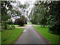
1
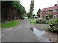
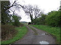
Bailey's Lane, Haddington
A cul-de-sac with a few modern houses in the tiny hamlet of Haddington. Looking north towards the public road.
Image: © Oliver Dixon
Taken: 19 Sep 2010
0.02 miles
3
Conduit
One of several water conduits like this in the area
Image: © Richard Croft
Taken: 3 Feb 2007
0.04 miles
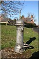
4
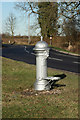
Water conduit
One of several 'Lion's-head' water hydrants installed hereabouts in the 1930s for communities not on the mains water supply
Image: © Richard Croft
Taken: 30 Jan 2010
0.05 miles
5
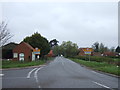
Bailey's Lane, Haddington
A cul-de-sac with a few modern houses in the tiny hamlet of Haddington. Looking south towards the blind end.
Image: © Oliver Dixon
Taken: 19 Sep 2010
0.06 miles