IMAGES TAKEN NEAR TO
Sycamore Drive, LINCOLN, LN5 9DR
Introduction
This page details the photographs taken nearby to Sycamore Drive, LN5 9DR by members of the Geograph project.
The Geograph project started in 2005 with the aim of publishing, organising and preserving representative images for every square kilometre of Great Britain, Ireland and the Isle of Man.

There are currently over 7.5m images from over14,400 individuals and you can help contribute to the project by visiting https://www.geograph.org.uk
Image Map
Images are licensed for reuse under creativecommons.org/licenses/by-sa/2.0
Notes
- Clicking on the map will re-center to the selected point.
- The higher the marker number, the further away the image location is from the centre of the postcode.
Image Listing (6 Images Found)
Images are licensed for reuse under creativecommons.org/licenses/by-sa/2.0
Image
Details
Distance
1
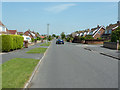
Redwood Drive
Suburban housing at Bracebridge
Image: © Richard Croft
Taken: 27 Jun 2011
0.03 miles
3
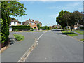
Redwood Drive
Suburban housing at Bracebridge
Image: © Richard Croft
Taken: 27 Jun 2011
0.21 miles
4
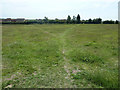
Waddington lowfields
Footpath near Brant Road on Waddington lowfields
Image: © Richard Croft
Taken: 27 Jun 2011
0.22 miles
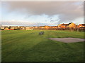
5
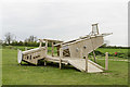
Crashed plane?
Children's play and climbing equipment, appropriately near RAF Waddington.
Image: © Julian P Guffogg
Taken: 20 Apr 2017
0.23 miles
6
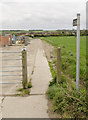
Footpath off Brant Road
The path leads through the playing fields to Station Road.
Image: © Julian P Guffogg
Taken: 20 Apr 2017
0.24 miles