IMAGES TAKEN NEAR TO
Calder Road, LINCOLN, LN5 9BB
Introduction
This page details the photographs taken nearby to Calder Road, LN5 9BB by members of the Geograph project.
The Geograph project started in 2005 with the aim of publishing, organising and preserving representative images for every square kilometre of Great Britain, Ireland and the Isle of Man.

There are currently over 7.5m images from over14,400 individuals and you can help contribute to the project by visiting https://www.geograph.org.uk
Image Map
Images are licensed for reuse under creativecommons.org/licenses/by-sa/2.0
Notes
- Clicking on the map will re-center to the selected point.
- The higher the marker number, the further away the image location is from the centre of the postcode.
Image Listing (9 Images Found)
Images are licensed for reuse under creativecommons.org/licenses/by-sa/2.0
Image
Details
Distance
1
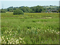
Bracebridge watermeadows
Witham-side rough pasture and watermeadow at Bracebridge
Image: © Richard Croft
Taken: 27 Jun 2011
0.06 miles
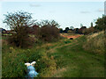
2
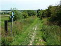
Stepping out
Footpath from the River Witham to Brant Road with the waymark showing a 'Stepping out' route along the river bank
Image: © Richard Croft
Taken: 27 Jun 2011
0.11 miles
3
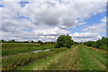
The River Witham near Bracebridge
The white building across the river is Manor Leas school in North Hykeham
Image: © Tim Heaton
Taken: 27 Jul 2014
0.13 miles
4
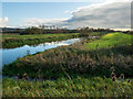
Confluence of the River Witham, North Hykeham
The channel on the right is the North Hykeham Pump Drain.
Image: © Oliver Mills
Taken: 4 Nov 2020
0.18 miles
9
North Hykeham Pump Drain, approaching Manor Farm
The footpath crosses the bridge and continues on the left side of the drain, which shortly connects to the River Witham.
Image: © Oliver Mills
Taken: 4 Nov 2020
0.24 miles