IMAGES TAKEN NEAR TO
Holly Street, LINCOLN, LN5 8RR
Introduction
This page details the photographs taken nearby to Holly Street, LN5 8RR by members of the Geograph project.
The Geograph project started in 2005 with the aim of publishing, organising and preserving representative images for every square kilometre of Great Britain, Ireland and the Isle of Man.

There are currently over 7.5m images from over14,400 individuals and you can help contribute to the project by visiting https://www.geograph.org.uk
Image Map
Images are licensed for reuse under creativecommons.org/licenses/by-sa/2.0
Notes
- Clicking on the map will re-center to the selected point.
- The higher the marker number, the further away the image location is from the centre of the postcode.
Image Listing (59 Images Found)
Images are licensed for reuse under creativecommons.org/licenses/by-sa/2.0
Image
Details
Distance
1

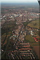
Misty Sunset
Looking over the Brant Road area of Lincoln from the hillside near Bracebridge Heath
Image: © John Bennett
Taken: 23 Dec 2007
0.12 miles
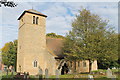
2

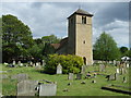
Bracebridge Hall Fishponds and All Saints Church
This photo was taken from the River Witham bank
Image: © John Bennett
Taken: 21 Aug 2005
0.12 miles
6
Bracebridge, up the Witham to Lincoln
Lincoln Cathedral visible at the top.
Image: © Chris
Taken: 11 Mar 2014
0.13 miles
9
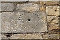
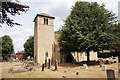
Mass Dial, All Saints' church, Bracebridge
Possibly relocated as the top is missing?
Image: © J.Hannan-Briggs
Taken: 21 Oct 2012
0.14 miles