IMAGES TAKEN NEAR TO
Brantley Mews, LINCOLN, LN5 8RQ
Introduction
This page details the photographs taken nearby to Brantley Mews, LN5 8RQ by members of the Geograph project.
The Geograph project started in 2005 with the aim of publishing, organising and preserving representative images for every square kilometre of Great Britain, Ireland and the Isle of Man.

There are currently over 7.5m images from over14,400 individuals and you can help contribute to the project by visiting https://www.geograph.org.uk
Image Map
Images are licensed for reuse under creativecommons.org/licenses/by-sa/2.0
Notes
- Clicking on the map will re-center to the selected point.
- The higher the marker number, the further away the image location is from the centre of the postcode.
Image Listing (60 Images Found)
Images are licensed for reuse under creativecommons.org/licenses/by-sa/2.0
Image
Details
Distance
1
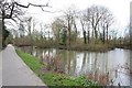
Bracebridge Hall fishponds
Former fishponds to Bracebridge Hall http://www.geograph.org.uk/photo/539824 by the River Witham
Image: © Richard Croft
Taken: 26 Jan 2008
0.02 miles
3
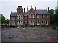
Grosvenor Hall
Built by Clarke in late 1800's, Grosvenor Hall, Bracebridge, Lincoln. Now a home for the elderly.
Image: © Elaine
Taken: 22 Sep 2005
0.03 miles
4
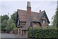
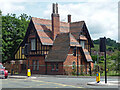
Former lodge
This house was built in around 1883 as the lodge (a large gatehouse) for Bracebridge Hall. The hall itself, now a nursing home, is a few hundred metres further northeast.
This is a grade II listed building - https://historicengland.org.uk/listing/the-list/list-entry/1388709?section=official-list-entry .
Image: © Bob Harvey
Taken: 4 Sep 2024
0.05 miles
5
Lodge, Newark Road, Lincoln
A picturesque affair complete with polychrome brick, timber framing, decorative tilework, and fretted bargeboards. Built 1883 for Bracebridge Hall, possibly by Albert Vicars who did the house (which is much less spirited). Grade II listed.
Image: © Stephen Richards
Taken: 15 Jun 2015
0.05 miles
6
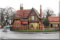
Bracebridge Lodge
Grade II listed, former lodge to Bracebridge Hall http://www.geograph.org.uk/photo/539824 built c1883 in a Tudor-Gothic Revival style
Image: © Richard Croft
Taken: 7 Mar 2012
0.05 miles
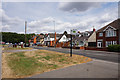
8
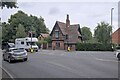
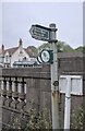
Road Junction
Road Junction in Bracebridge. The A1434 is Newark Road - it used to be the A46 until Lincoln was bypassed. The other road is Brant road, but in fact it continues out of Bracebridge along the high ground through several villages, and was obviously an important route in medieval times.
Image: © Bob Harvey
Taken: 4 Sep 2024
0.05 miles
9
Footpath sign
The bank of the Witham is a permissive footpath, and part of the "stepping out" path network organised by North Kesteven District Council (https://www.hillholtwood.co.uk/stepping-out-walks ).
Image: © Bob Harvey
Taken: 4 Sep 2024
0.05 miles
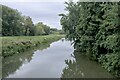
10
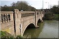
Brace Bridge
View across the River Witham
Image: © Richard Croft
Taken: 26 Jan 2008
0.05 miles