IMAGES TAKEN NEAR TO
Newark Road, LINCOLN, LN5 8QF
Introduction
This page details the photographs taken nearby to Newark Road, LN5 8QF by members of the Geograph project.
The Geograph project started in 2005 with the aim of publishing, organising and preserving representative images for every square kilometre of Great Britain, Ireland and the Isle of Man.

There are currently over 7.5m images from over14,400 individuals and you can help contribute to the project by visiting https://www.geograph.org.uk
Image Map
Images are licensed for reuse under creativecommons.org/licenses/by-sa/2.0
Notes
- Clicking on the map will re-center to the selected point.
- The higher the marker number, the further away the image location is from the centre of the postcode.
Image Listing (26 Images Found)
Images are licensed for reuse under creativecommons.org/licenses/by-sa/2.0
Image
Details
Distance
2
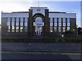
255 Newark Road
1938 offices of the Lincoln Walkers site was originally the home of Smiths Potato Crisps (1929) Ltd. The plot was previously occupied by a nursery and the architect for the new building was A E Powell of Bristol. Officially inaugurated on 20th July 1938 The Lincolnshire Chronicle on 23rd July 1938 headlined with 'A £75,000 Enterprise: Work for 600 People'. Initially potatoes from Frank Smiths Nocton estate were processed here but crisp production ceased in 1966 with a switch to snack foods such as Quavers and Chipsticks. In 1993 Smiths merged with Walkers Snack Foods that in addition to Quavers made some of the Walkers Sensations range here. 1997 saw the rebranding of Quavers under the Walkers name and logo. In September 2021 LincolnshireLive reported that “£24 million is being invested in the Walkers factory in Lincoln to satisfy public demand for Quavers - produced at the site for 50 years” and that it “safeguard 172 jobs”.
Image: © Jo and Steve Turner
Taken: 14 Feb 2011
0.03 miles
3
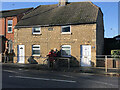
267-269 Newark Road, Lincoln
A pair of stone-built houses, with an 1841 date stone. Both 2 bedroom cottages, no.269 has been extended more than doubling its footprint giving the cottage a total area of about 75 sq m. No.267 has also been extended but to a lesser degree, probably by the addition of a kitchen.
Image: © Jo and Steve Turner
Taken: 25 Nov 2022
0.03 miles
4
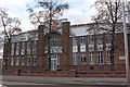
HSL Chairs, 150 Newark Road, Lincoln
This was originally Lincoln Tramways Company three bay tram depot. The 1888 OS map shows only one track entering the centre bay but a later photograph shows 3 tracks. It has a datestone of 1882 but the frontage was rebuilt in 1905 to accommodate the increased height of the new electric double-decker cars. The horse tram service assets were purchased by the Lincoln Corporation in July 1904 for the sum of £10,488. After trial running which started on 29 October 1905, the tramway opened for public service on 23 November 1905 with eight tramcars purchased from the Brush Electric Company of Loughborough. It operated as a depot throughout life of the tramway, 1882 to the end of 1929. In 1930 it was let to Mrs E Crack for a motor body building workshop. Bracebridge Motor Body Works occupied the building until 1957 and were then followed by Hutson's garage up to the 1970s . After Hutson's it remained empty and for sale until late 2002 when it was converted to retail and offices. Rails were discovered throughout the building that were retained under a new floor laid over a damp proof membrane. In 2003 it was turned over to a retail shop, Hein Gericke Ltd who were here until sometime after a takeover late in 2012. HSL (High Seat Limited) were in here by November 2015.
Image: © Jo and Steve Turner
Taken: 25 Nov 2022
0.04 miles
5

Newark Road
Looking south by the corner with Urban Street
Image: © Richard Croft
Taken: 3 Mar 2008
0.08 miles
6
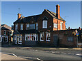
Gatehouse Inn, 178 Newark Road, Lincoln
The Craft Union Pub Company Inn has a datestone for 1885. In the 19th century, the area was listed under Bracebridge 'a small scattered village' not as part of Lincoln. White's 1872 directory lists in Bracebridge 'Speed Thomas, victualler, Gate'. As you will see, Mrs Speed, presumably his wife, is in the Gatehouse in 1885. The conclusion is that this building replaced an earlier pub. I can't find it in directories that I have before 1872. (Late 19th & early 20th century there is another Gatehouse Hotel listed in Canwick Road). In June 2022 Stonegate Group reported on their website that the Inn was open again after a £200,000 makeover. A search of my directories found the following landlords; 1885 Mrs Catherine Speed, listed as Gate House P.H.; 1889 Robert Hoe, listed as Gate House P.H.; 1894-1926 Thomas Brown; 1930 Mrs Mary A Brown; 1946 Frederick G Brown; 1965 just listed as Gatehouse Hotel.
Image: © Jo and Steve Turner
Taken: 25 Nov 2022
0.11 miles
7

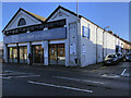
Evans Halshaw
Car dealers on Newark Road
Image: © Richard Croft
Taken: 3 Mar 2008
0.11 miles
8

Evans Halshaw
Large car dealers in Lincoln
Image: © Richard Croft
Taken: 3 Mar 2008
0.12 miles
9
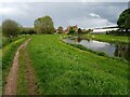
River Witham north of Bracebridge, Lincoln
A public footpath follows a bend of the River Witham, looking northeastwards towards a residential area approximately 2.5 kilometres south of Lincoln city centre and 600 metres north of Bracebridge bridge.
This photograph was taken on a warm, overcast day in early May. Viewed from the largely undeveloped western bank of the Witham between Bracebridge and Dixon Street, the riverside homes on the corner of Fairfax Street and Park Lane can be seen (centre) with the white rear of the Aldi supermarket on Newark Road (A1434) extending into frame from the right.
Though much of this footpath is insulated from the noises of the city, here the sounds of ducks splashing and birds chirping are unfortunately drowned out by the constant hum of the local Walkers crisp factory, whose fenced yard of grimy container lorries lines the opposite bank just upstream (south) of this point.
Image: © Jonathon Pile
Taken: 9 May 2023
0.13 miles
10

Lincoln, 193 Newark Road
On the angle facing Manby Street is a cut bench mark. See http://www.geograph.org.uk/photo/4765511 for a close-up and http://www.bench-marks.org.uk/bm37956 for details.
Image: © Brian Westlake
Taken: 14 Dec 2015
0.14 miles