IMAGES TAKEN NEAR TO
Boundary Street, LINCOLN, LN5 8PQ
Introduction
This page details the photographs taken nearby to Boundary Street, LN5 8PQ by members of the Geograph project.
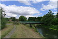
The Geograph project started in 2005 with the aim of publishing, organising and preserving representative images for every square kilometre of Great Britain, Ireland and the Isle of Man.

There are currently over 7.5m images from over14,400 individuals and you can help contribute to the project by visiting https://www.geograph.org.uk
Image Map
Images are licensed for reuse under creativecommons.org/licenses/by-sa/2.0
Notes
- Clicking on the map will re-center to the selected point.
- The higher the marker number, the further away the image location is from the centre of the postcode.
Image Listing (49 Images Found)
Images are licensed for reuse under creativecommons.org/licenses/by-sa/2.0
Image
Details
Distance
1
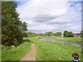
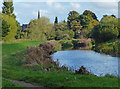
River Witham looking North
The Witham heads towards Lincoln
Image: © Rob Smith
Taken: 29 May 2006
0.03 miles
2

The River Witham in Bracebridge, Lincoln
Next to the Russell Street Bridge.
Image: © Mat Fascione
Taken: 19 Oct 2015
0.03 miles
3
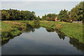
River Witham
View downstream from Russell Street footbridge
Image: © Richard Croft
Taken: 28 Sep 2013
0.04 miles
4
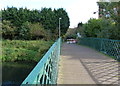
Russell Street Bridge in Bracebridge
Crossing the River Witham.
Image: © Mat Fascione
Taken: 19 Oct 2015
0.05 miles

6
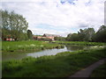
New Housing Near the River Witham Lincoln
Despite being close to the river, Lincolns excellent flood defence plan should keep these houses safe.
Image: © Rob Smith
Taken: 29 May 2006
0.06 miles
7
Russell Street Bridge, Bracebridge
This bridge over the River Witham originally carried a private road to Boultham Hall, but when no longer needed (another bridge being built) was moved to its present site in 1924 to serve as a footbridge http://microsites.lincolnshire.gov.uk/upload/public/attachments/793/Bracebridge_Walk_Leaflet_printable_version.pdf
Image: © Tim Heaton
Taken: 27 Jul 2014
0.07 miles
8
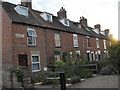
Otter's Cottages, off Newark Road, Lincoln
Row of 9 Victorian 3 bedroomed, terraced cottages with date stone reading 'Otter's Cottages 1880', situated off unadopted pathway just off Newark Road, close to St. Catherine's area
Built of red brick, originally with slate roofs to front and red clay pantile to rear; only 2 cottages now retain original Georgian-style timber sash windows.
Each cottage has a privy [now disused!] and coal shed to rear; the smallest 1st floor bedroom in numbers 2 thro' 9 has been converted to a bathroom. Number 1 has a modern, single storey bathroom / utility extension to the rear, built late 1980's.
As at August 2009, new build of 4 small terraced cottage-style houses being erected on land due west of Otter's Cottages; this area was originally part of 'Otter's Field' and freeholders of Otter's Cottages held the right to drive pigs down to the field twice a year.
Image: © Rory
Taken: 31 Aug 2009
0.11 miles
9
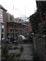
New build, west of Otter's Cottages
4 new cottage-style dwellings currently being erected on land to west of Otter's Cottages as at August 2009.
Image: © Rory
Taken: 31 Aug 2009
0.11 miles
10
River Witham at St Catherine's, Lincoln
With the spire of St Katherine's Church behind the trees.
Image: © Mat Fascione
Taken: 19 Oct 2015
0.11 miles