IMAGES TAKEN NEAR TO
Cross O'Cliff Close, LINCOLN, LN5 8PP
Introduction
This page details the photographs taken nearby to Cross O'Cliff Close, LN5 8PP by members of the Geograph project.
The Geograph project started in 2005 with the aim of publishing, organising and preserving representative images for every square kilometre of Great Britain, Ireland and the Isle of Man.

There are currently over 7.5m images from over14,400 individuals and you can help contribute to the project by visiting https://www.geograph.org.uk
Image Map
Images are licensed for reuse under creativecommons.org/licenses/by-sa/2.0
Notes
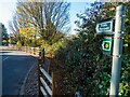
- Clicking on the map will re-center to the selected point.
- The higher the marker number, the further away the image location is from the centre of the postcode.
Image Listing (23 Images Found)
Images are licensed for reuse under creativecommons.org/licenses/by-sa/2.0
Image
Details
Distance
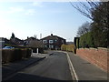
2
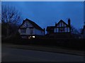
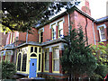
29-31 Cross O'Cliff Hill, Lincoln
Pair of semi-detached houses shown on the 1905 OS map but not the 1886 OS map. Note that the properties are not symmetrical, no.29 occupying only the section with the gable end to the road, 31 having the centre section. Directories I have list them in 1913 but not 1897, suggesting a build date between 1898 and 1904. 1913 they are called 'The Croft' (29, apparently empty) and 'Brentwood' (31). By 1919, now occupied, no. 29 is 'Strathmore' and is shown in 1965 Kelly’s as two flats. 31 has subsequently been converted to at least 5 flats.
Image: © Jo and Steve Turner
Taken: 25 Nov 2022
0.05 miles
4
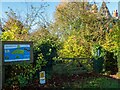
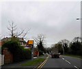
Entrance to Cross o'Cliff Orchard
Located off Cross o'Cliff Hill (A15).
Image: © Oliver Mills
Taken: 4 Nov 2020
0.07 miles
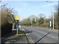
7
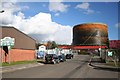
Clayton Road
Light industrial units dwarfed by the gasometer on Clayton Road
Image: © Richard Croft
Taken: 3 Mar 2008
0.11 miles
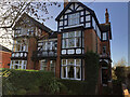
8
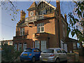
Ashleigh, 9 Cross O'Cliff Hill, Lincoln
House built for John Lodge (MD Wagon & Engine Co.) architect W Mortimer and Son to planning granted in April 1897. Garage and greenhouse added in 1912. Apparently called Ashleigh from new. In October 2013 planning was granted for conversion to 4 flats. In the grounds to the rear is an annex to be converted to two flats. Prior to this the property had been a training facility for some time, owned by Lincolnshire County Council. Access to 6 parking spaces at the rear had been accessed through a private driveway within the ownership of no. 11.
Image: © Jo and Steve Turner
Taken: 25 Nov 2022
0.12 miles
9
Footpath on Orchard Walk, Lincoln
This footpath eventually leads to the Viking Way, running over the Lincoln Cliff, South of the city.
Image: © Oliver Mills
Taken: 4 Nov 2020
0.14 miles
10
5 Cross O'Cliff Hill, Lincoln
It seems to have been built between 1897 and 1913 and called 'Hill Rise'. It is not shown on the 1905 OS map. There are two potential candidates in the planning files, one 1905 and one 1908. It appears to have some substantial outbuildings to the rear. Unusually it has retained the original iron railings on the roadside, most having been removed for the metal in WWII.
Image: © Jo and Steve Turner
Taken: 25 Nov 2022
0.14 miles