IMAGES TAKEN NEAR TO
Fairfax Street, LINCOLN, LN5 8NR
Introduction
This page details the photographs taken nearby to Fairfax Street, LN5 8NR by members of the Geograph project.
The Geograph project started in 2005 with the aim of publishing, organising and preserving representative images for every square kilometre of Great Britain, Ireland and the Isle of Man.

There are currently over 7.5m images from over14,400 individuals and you can help contribute to the project by visiting https://www.geograph.org.uk
Image Map
Images are licensed for reuse under creativecommons.org/licenses/by-sa/2.0
Notes
- Clicking on the map will re-center to the selected point.
- The higher the marker number, the further away the image location is from the centre of the postcode.
Image Listing (33 Images Found)
Images are licensed for reuse under creativecommons.org/licenses/by-sa/2.0
Image
Details
Distance
1
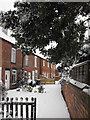
Otter's Cottages New Build
February 2010
Otter's Cottages new build [Number 10 thro' 13] now completed; visible beyond the wooden fence in this photo.
Original row of 9 cottages built 1880; the new homes are built in a sympathetic red brick and the dentil brickwork pattern seen on the older cottages has been matched at the eaves, however the new homes do not have an attic room - nor chimney stacks, which makes them look a little odd!
Image: © Rory
Taken: 21 Feb 2010
0.04 miles
2

Lincoln, 193 Newark Road
On the angle facing Manby Street is a cut bench mark. See http://www.geograph.org.uk/photo/4765511 for a close-up and http://www.bench-marks.org.uk/bm37956 for details.
Image: © Brian Westlake
Taken: 14 Dec 2015
0.07 miles
3
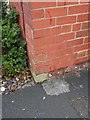
Cut Mark: Lincoln, 193 Newark Road
A cut bench mark on the side of no.193 Newark Road, on the corner of Manby Street. See http://www.geograph.org.uk/photo/4765514 for a wider view and http://www.bench-marks.org.uk/bm37956 for details.
Image: © Brian Westlake
Taken: 14 Dec 2015
0.07 miles
4
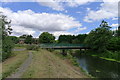
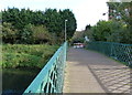
Russell Street Bridge, Bracebridge
This bridge over the River Witham originally carried a private road to Boultham Hall, but when no longer needed (another bridge being built) was moved to its present site in 1924 to serve as a footbridge http://microsites.lincolnshire.gov.uk/upload/public/attachments/793/Bracebridge_Walk_Leaflet_printable_version.pdf
Image: © Tim Heaton
Taken: 27 Jul 2014
0.08 miles

6
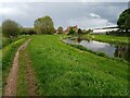
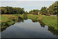
River Witham north of Bracebridge, Lincoln
A public footpath follows a bend of the River Witham, looking northeastwards towards a residential area approximately 2.5 kilometres south of Lincoln city centre and 600 metres north of Bracebridge bridge.
This photograph was taken on a warm, overcast day in early May. Viewed from the largely undeveloped western bank of the Witham between Bracebridge and Dixon Street, the riverside homes on the corner of Fairfax Street and Park Lane can be seen (centre) with the white rear of the Aldi supermarket on Newark Road (A1434) extending into frame from the right.
Though much of this footpath is insulated from the noises of the city, here the sounds of ducks splashing and birds chirping are unfortunately drowned out by the constant hum of the local Walkers crisp factory, whose fenced yard of grimy container lorries lines the opposite bank just upstream (south) of this point.
Image: © Jonathon Pile
Taken: 9 May 2023
0.08 miles
7
Russell Street Bridge in Bracebridge
Crossing the River Witham.
Image: © Mat Fascione
Taken: 19 Oct 2015
0.09 miles
8

Evans Halshaw
Car dealers on Newark Road
Image: © Richard Croft
Taken: 3 Mar 2008
0.09 miles
9

Evans Halshaw
Large car dealers in Lincoln
Image: © Richard Croft
Taken: 3 Mar 2008
0.10 miles
10
River Witham
View downstream from Russell Street footbridge
Image: © Richard Croft
Taken: 28 Sep 2013
0.11 miles